Honolulu is starting Tuesday with partly cloudy skies and a comfortable 70°F at Daniel K. Inouye International Airport, with a sunny high near 81°F expected. Coastal conditions are rough, as a Coastal Flood Statement is in effect through noon on Tuesday, and a High Surf Warning covers exposed north and west shores through 6 p.m. on Wednesday. An extra-large northwest swell, combined with higher water levels, is increasing the risk of minor coastal flooding and overwash during overnight and early morning high tides.
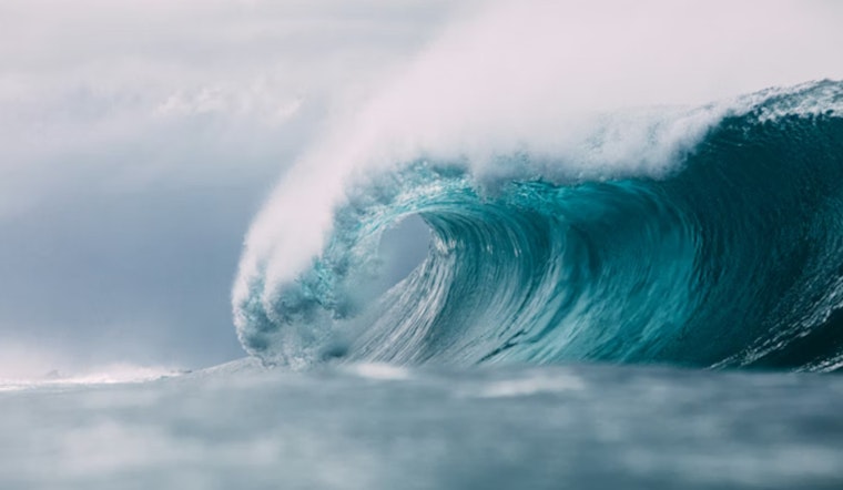
High Surf And Coastal Flooding
Surf is forecast to build to 35 to 45 feet along exposed north-facing shores, 20 to 30 feet along west-facing coasts of the smaller islands, and 8 to 12 feet along west Hawaii (the Big Island) on Tuesday afternoon. Overwash onto low-lying roads, docks and beaches is likely, and waves breaking across channel entrances could make navigation tricky at best and hazardous at worst. Officials urge everyone to stay well back from the shoreline and be ready for possible road closures, according to the National Weather Service.
Tuesday Through Thursday
Farther inland in Honolulu, the weather story looks much calmer. Mostly sunny skies and warm highs around 81°F are expected, with light north to northwest winds around 5 to 8 mph. Nights should dip into the mid-60s. Drier air spreads across the islands by midweek, setting up mostly clear evenings on Wednesday, Feb. 4, 2026. On the water, though, it stays busy: a Small Craft Advisory is in effect through 6 p.m. HST Wednesday, Feb. 4, 2026 for many local waters, so smaller boats will want to take note.
Weekend Outlook
The pattern looks more complicated late Friday into the weekend as a frontal system slides in and stalls over the islands. Forecasters say that could deliver heavier showers, isolated thunderstorms and strong northeast winds by Sunday, Feb. 8, 2026. Gusts up to 40 mph are possible in exposed spots, and frequent downpours could trigger flash flooding in windward and mountain areas. Anyone planning outdoor events for Saturday or Sunday might want a backup plan and should watch for forecast updates in case conditions go downhill.
What To Do
Avoid walking or driving on wet beaches and never try to drive through flooded roads. If you live near the shoreline, move vehicles and valuables to higher ground. Secure canoes, kayaks and other small craft, follow lifeguard instructions and posted closures, and hold off on channel crossings until the surf backs down. If you can safely document flooding, consider sharing photos with the University of Hawai‘i Sea Grant King Tides project to help scientists track coastal impacts.
For background on the larger storm pattern that set the stage for this event, revisit our Jan. 4 coverage on the stormy setup forecasters flagged in early January. We will post updates if watches or warnings change.


