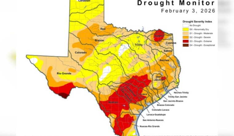
After two months of bad drought news, Texas got a small bit of relief. The amount of land listed as “abnormally dry” went down slightly, now covering about 28% of the state. Some light rain helped parts of the Gulf Coast and south-central Texas, but officials say it’s not a real recovery yet. Serious drought conditions are still affecting West Texas and the Panhandle, according to the Texas Commission on Environmental Quality.
In a post on X, the Texas Commission on Environmental Quality highlighted the latest weekly drought map, noting that the area in drought decreased from the previous week, marking the first weekly decline in eight weeks. The agency linked to the new map and said it was prepared by its Water Availability Division using the U.S. Drought Monitor dataset. According to the Texas Commission on Environmental Quality, abnormally dry conditions now affect roughly 28% of Texas.
The latest map shows a decrease in drought area from the previous week, the first weekly decline in eight weeks. Abnormally dry conditions are impacting 28% of the state. The latest map is available at https://t.co/fwfc8Ie384. #TXWater #TXDrought pic.twitter.com/8m299gOpXv
— Texas Commission on Environmental Quality (@TCEQ) February 6, 2026
What the U.S. Drought Monitor Map Says
The weekly map driving this update is the U.S. Drought Monitor product for the week ending Feb. 3. The U.S. Drought Monitor page notes, “Map released: February 5, 2026; Data valid: February 3, 2026.” The monitor uses five categories, from D0 (abnormally dry) through D4 (exceptional drought), to capture both short and long-term impacts. According to the U.S. Drought Monitor, that dataset is the basis for the graphics TCEQ posted this week.
Where Things Improved and Where They Did Not
The U.S. Drought Monitor shows spotty improvements in parts of southeast and south-central Texas, where recent rains trimmed short-term deficits. Other regions did not share in the luck. The Panhandle and much of West Texas remain locked in severe to exceptional drought. The weekly summary notes one-category improvements in areas that saw the heaviest precipitation and one-category degradations elsewhere, leaving a patchwork of conditions across the state. That uneven picture helps explain how the statewide dry footprint can shrink a bit even while deep drought continues in large swaths of Texas.
What Officials and Water Managers Are Advising
TCEQ is urging public water systems and utilities to stick with their drought contingency plans and to report any mandatory restrictions through the agency’s reporting tools. According to TCEQ, the agency offers technical assistance and guidance to systems under stress and provides resources for both utilities and the public. Local water providers set the rules for customers and remain the first point of contact for Texans who want to know whether new restrictions apply in their area.
Short-term Outlook
The near-term forecast is a mixed bag. Recent pockets of beneficial rain helped parts of the Gulf Coast and some south-central counties, but broader outlooks still lean toward drier conditions across central and southern Texas, with no sustained wet pattern on deck. Federal outlooks and the national drought portal point to limited chances for a full-scale recovery unless the state sees several weeks of measurable rain. For the latest maps and short-term projections, see Drought.gov.
This week’s modest improvement is a reminder that drought is highly dynamic. A few well-timed showers can nudge the map’s dry acreage down, even while long-running hydrologic shortages linger beneath the surface. Officials say the practical play for now is steady monitoring, consistent conservation and close attention to local water-supplier guidance, as any broad statewide recovery remains uneven and incomplete.


