St. Tammany Parish emergency crews want North Shore residents thinking about the weather before they turn out the lights Friday night, not after the thunder starts rattling windows.
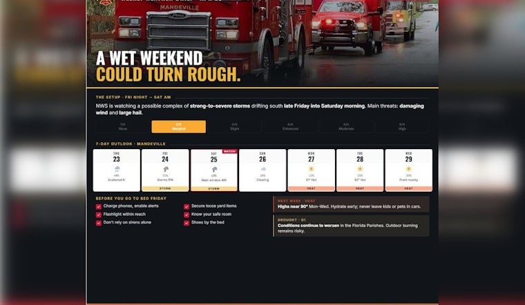
Forecasters are tracking a possible overnight cluster of strong to severe storms expected to move into North Shore communities late Friday into early Saturday, with the primary threats being damaging wind gusts and large hail. In a Thursday evening post, Mandeville Fire/EMS District 4 urged people to handle a few quick chores before bed so they are not scrambling in the dark if things go sideways overnight.
Officials are also eyeing what comes after the storms. Rising heat early next week and worsening drought across the Florida Parishes could boost wildfire risk and make any post-storm clean-up a hotter, riskier ordeal. Regional forecasters are still watching an unstable pattern across the Deep South, and local crews are clearly not in the mood for surprises.
The advisory from Mandeville Fire/EMS District 4 relayed guidance from federal forecasters and laid out a simple game plan: turn on Wireless Emergency Alerts, decide which interior room you will use as a safe spot, and stash a flashlight and a pair of shoes by the bed Friday night. The department also suggested tying down or bringing in loose yard items and patio furniture and reminded residents that outdoor burning remains a bad idea while drought conditions drag on.
Overnight Storm Complex On The Radar
According to NWS New Orleans/Baton Rouge, a complex of strong to severe thunderstorms could develop late Friday night and roll into southeast Louisiana into Saturday morning. Parts of the region are in a Marginal, or level 1 of 5, severe weather risk for Friday night, with isolated damaging winds and quarter-size hail topping the concern list.
The Storm Prediction Center outlook highlights the potential for storms to dive southeast out of the Plains overnight, which could increase the chances of outflow-driven wind damage in some spots. Officials want residents to think now about where they will shelter if conditions deteriorate in the middle of the night, not while the power is flickering.
Simple Steps Officials Want You To Take
Mandeville Fire/EMS is not asking for a full bunker build, just a short checklist: pick an interior, windowless room in advance as your shelter area, make sure Wireless Emergency Alerts are enabled on your phone, and set a flashlight and sturdy shoes where you can grab them quickly if you need to move fast.
The department’s advisory from Mandeville Fire/EMS District 4 also urged residents to secure patio furniture and other loose outdoor items that can become projectiles, warned that outdoor burning is particularly risky under current conditions, and reminded the public to call 911 to report emergencies.
Heat And Drought Pile On The Hazards
The storm threat is only one part of the story. The National Weather Service’s April 16 Drought Information Statement, available from the National Weather Service, reports that much of southern Louisiana is now in drought, including pockets of Severe (D2) and Exceptional (D3) conditions, and warns that fire danger is elevated across the region.
The fire district’s advisory also pointed to a warming trend into next week, with forecasts calling for highs near 90 and heat indices in the mid 90s. The post specifically notes temperatures of roughly 91°F on Monday and about 92°F on Tuesday, a combo that can quickly turn storm cleanup or any outdoor work into a grind. Officials are urging residents to respect local burn bans and take standard heat precautions, especially for anyone working outside.
When To Watch And How To Get Alerts
Forecasters expect the highest chance of storms overnight Friday into Saturday morning, with some scattered redevelopment possible Saturday afternoon. In other words, this is a full-weekend “keep an eye on the sky” situation rather than a quick hit-and-done event.
The Storm Prediction Center outlook provides updated probabilities and timing as the setup evolves. Local officials recommend keeping phones charged and set to receive Wireless Emergency Alerts and having a battery-powered radio or NOAA Weather Radio as a backup. If watches or warnings are issued, the goal is simple: move quickly to that preplanned shelter spot and ride it out safely.


