A tornado touched down in Fresno County Tuesday afternoon, according to the National Weather Service, snapping and uprooting trees across a rural stretch northeast of Clovis and jolting the Central Valley with blaring cellphone alerts. Tornado warnings briefly sent students in several local school districts into shelter-in-place mode while the same spring storm system churned out damaging straight-line winds and reports of other short-lived tornadoes farther west and to the north.
The NWS confirmed a touchdown roughly 11 miles northeast of Clovis shortly after 5 p.m., and a damage assessment team reported tree damage consistent with an EF1 tornado around 5:24 p.m., according to CBS San Francisco. An EF1 corresponds to winds in the 86 to 110 mph range. The Storm Prediction Center also logged damaging winds and downed trees in Merced County tied to the same storm system, officials said.
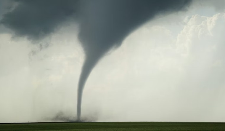
What crews found near Clovis
Survey teams from the National Weather Service documented snapped trunks and uprooted trees and noted a barn roof torn off near one damage site, according to images and field notes cited by the Los Angeles Times. That report quotes a Hanford-based meteorologist who said the strongest tornado near Clovis produced observed gusts up to 125 mph, while stressing that official EF ratings are based on what damage crews find on the ground. NWS officials said teams remain in the field working to map the tornado’s track and measure the full scope of impacts.
Schools, warnings and eyewitness accounts
As warnings lit up phones across the region, emergency alerts prompted Clovis Unified and other districts to order brief shelter-in-place actions while tornado warnings were active, according to local reporting. The Fresno Bee and other outlets published video and photos of a funnel cloud near Highway 99 and Herndon Avenue, while the San Francisco Chronicle reproduced the NWS alert urging residents to “TAKE COVER NOW!” and move to an interior room away from windows.
How unusual is this for the Valley?
Tornadoes are relatively rare in California, and the Central Valley usually sees only a handful of brief touchdowns in a typical year. Meteorologists said Tuesday’s setup, with warm air near the surface colliding with very cold air higher up, boosted the odds of rotating storms. Statewide forecasts and summaries noted multiple confirmed tornado reports from the day, an unusually active stretch for April in this part of the state, according to the Los Angeles Times.
What residents should do
The NWS advises people in affected counties to stay tuned to official alerts and to seek shelter immediately if tornado warnings are issued, avoiding mobile homes and vehicles when possible. For the latest local warnings and storm products from the office conducting the damage survey, visit NWS Hanford.
Assessments and cleanup are still underway. County officials said there were no immediate reports of serious injuries but urged residents to steer clear of downed trees and power lines as crews continue to address damage in and around Clovis, Merced and Atwater, according to local reports. This story will be updated as agencies release more detailed damage surveys and advisories.


