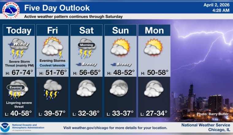
Chicago woke up to light rain and temperatures in the low 40s on Thursday, April 2, 2026, and that is just the warmup act. Rounds of showers and thunderstorms are expected through the day, with inland highs climbing into the upper 60s. The afternoon and evening look the most problematic, as gusty southerly winds and heavy rain could lead to ponding on roads and scattered power outages.
Afternoon Winds Crank Up
A Wind Advisory covers much of the Chicago area from 1 p.m. to 7 p.m. CDT on Thursday, April 2, while some nearby counties have advisories starting as early as 10 a.m. Forecast south-southeast winds will run 15 to 30 mph, with gusts up to 45 mph, strong enough to make driving a two-hands-on-the-wheel situation.
The advisory notes that "Winds this strong can make driving difficult, especially for high profile vehicles. Use extra caution." Temperatures should peak near 69°F before sliding back into the mid 60s later in the afternoon. For the official advisory and latest timing, see NWS Chicago.
Storm Timing And Severe Threat
Showers and thunderstorms are expected to develop before 9 a.m. and continue on and off into the evening. Localized downpours in heavier cells could drop 1 to 2 inches of new rainfall.
The greatest severe threat is roughly between 5 p.m. and 9 p.m. Thursday, when more organized storms could produce damaging winds and isolated tornadoes, especially along and west of I-39. Storms are expected to move eastward through the evening, although gusty winds may hang on into the night.
Commute, Lakefront And Safety
Both the morning and evening rush hours could turn sloppy, with soggy, slower commutes and ponding on roads. Reduced visibility is likely wherever heavier downpours set up, so headlights and patience will be your friends.
On the lakefront, boaters and other water users should heed existing Small Craft Advisories and the Gale Warning for the nearshore waters, with choppy and hazardous conditions from the afternoon into the evening. It is a good day to secure loose patio furniture, tie up boats, and avoid exposed bridges while winds are at their peak.
What To Do
Allow extra travel time, and do not drive through flooded streets, even if the water looks shallow. Bring in or secure outdoor items before the advisory window so they do not turn into airborne projectiles. If thunderstorms intensify, head indoors and follow local emergency messages until any watches or warnings are cleared.
Earlier Coverage
We published an initial outlook on April 1, and this update tightens the timing and adds the Wind Advisory for Thursday afternoon and evening. Read our earlier rough Thursday forecast.


