Central Texans rolled out of bed to a wall of humidity Wednesday, with Austin starting the morning cloudy, muggy and stuck near 75°F. Humidity is hovering around 90 percent, and low clouds plus patches of light drizzle or mist may hang on through the mid-morning commute, leaving some roads and bridges slick. Southerly breezes are light for now, and most neighborhoods are still expected to climb into the mid 80s by this afternoon before a cold front shows up late tonight.
Afternoon Storm Chances
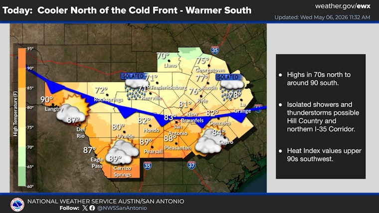
Forecasters are calling for a slight chance of showers and thunderstorms on Wednesday, May 6, mainly between about 7 a.m. and 4 p.m., with a high near 86°F and roughly a 20 percent chance of precipitation. According to the NWS Austin/San Antonio, rain and storm chances sit in the low to medium range, about 20 to 50 percent, for the middle through the end of the week. Most spots will likely stay dry, but the approaching cold front could still fire up a few stronger cells, with a higher conditional threat highlighted across Williamson, Lee, parts of Fayette and northern Bastrop counties.
Behind that front, temperatures drop noticeably into Thursday, May 7, with highs only in the low 70s and north-northeast winds around 10 mph, gusting up to about 25 mph, per the NWS Austin/San Antonio.
Late-Night Showers And Thursday Cooldown
Showers and a few storms could redevelop after midnight Wednesday into the pre-dawn hours of Thursday, setting up a cooler, breezy day in the front's wake. If you have outdoor plans Thursday afternoon, plan on a light extra layer, especially if you will be out on ridge tops or exposed bridges where gusts will be strongest.
The low ceilings and mist early this morning may also briefly affect flights and the commute, so travelers heading out of Austin-Bergstrom should check in with their airline for any potential hiccups.
Looking Ahead
Rain chances tick up again on Friday, May 8, with scattered showers and thunderstorms possible and highs near 80°F. After that, temperatures rebound into the mid 80s to upper 80s over the weekend, with only spotty storm chances hanging around.
As the heat builds back in later in the week, residents can find information on cooling centers and city services through the City of Austin, and should keep an eye on updated forecasts from the NWS Austin/San Antonio before locking in outdoor plans.


