A blink-and-you-missed-it funnel cloud dropped out of a rain shower over southwest Seattle near Normandy Park on the evening of Saturday, May 16, giving a quick scare and a few dramatic photos before vanishing. The narrow condensation funnel was visible only for a few moments before fading, and forecasters said there were no immediate reports of damage.
NWS forecaster Jacob DeFlitch told The Seattle Times that the brief feature was tied to a rotating shower as it moved through and "probably lasted less than a minute." According to the paper, the weather service did not receive any damage reports and noted the sighting came as a line of unstable, showery weather moved across the region.
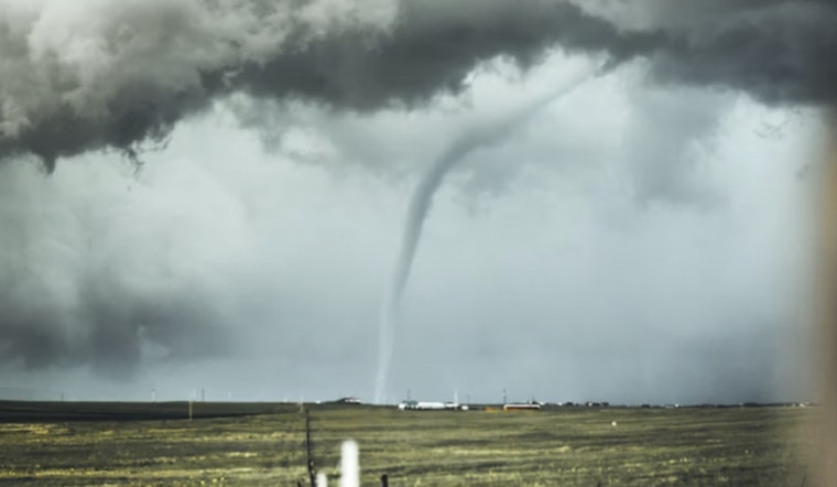
University of Washington atmospheric scientist Cliff Mass labeled the episode a "weak tornadic event" and shared radar images along with a funnel photo on his blog. Mass explained that even modest convective showers can spin up short-lived funnels in the Puget Sound environment when the right low-level winds and wind shear line up.
Where and when
Spotters reported the funnel near the shoreline around Normandy Park, visible from parts of southwest Seattle at roughly 8 p.m. on May 16. The brief show followed an April waterspout that formed about three miles west of Magnolia earlier this spring, another rare marine funnel that caught plenty of attention around Puget Sound, as reported by The Seattle Times.
Funnel cloud versus waterspout
A funnel cloud is a column of condensed water vapor that stretches down from the base of a cloud but does not reach the surface, according to the National Weather Service. A waterspout, by contrast, is generally described as a tornado that develops over water, a distinction highlighted in coverage of recent Puget Sound video by National Geographic.
Why funnels can show up here
Mass said Puget Sound convergence zones, combined with rapid changes in wind speed or direction with height, can stretch and spin up weak vortices when unstable showers form over the Sound. Those local dynamics, together with cooler air aloft sliding over relatively warmer water this spring, favor brief, showery funnels rather than a long-lived tornado outbreak.
How to report and stay safe
The National Weather Service urges anyone who spots a funnel cloud to note the exact time and location, then share photos or video with local NWS offices or official spotter channels. That information helps forecasters confirm rotation and gauge any threat. If a storm is bearing down on your area, move indoors, stay away from windows, and skip the urge to drive toward or film the funnel up close. Safety officials stress that any rotating funnel, even if it looks weak or short-lived, should be treated as potentially dangerous.


