Out on Colorado's high ridges, where the wind usually gets all the blame for fire danger, scientists are making the case that the real action is happening underfoot. A growing group of researchers and land managers says tracking how wet or dry the soil is could sharpen wildfire forecasts in ways that traditional weather and drought maps simply cannot match.
Last summer, research teams spread out across Independence Pass and other high-country slopes, hauling handheld probes and checking buried sensors to see just how much water the ground was actually holding. Those fine-scale readings, taken across gullies, ridgelines, and shady pockets, are already feeding into local decisions about when to light prescribed burns, where to thin forests, and which streamside areas to restore before fire season ramps up.
As reported by The Colorado Sun, an Aspen Global Change Institute field campaign in July 2025 racked up between 15,000 and 17,000 soil moisture readings around Independence Pass and spotlighted a growing web of sensors in places like the Roaring Fork Valley that ping out data every hour. Local groups such as the Colorado River Wildfire Collaborative are now pairing those soil trends with satellite feeds and weather forecasts to guide on-the-ground mitigation work in Garfield County.
Soil Moisture Beats Weather in Key Fire Spread Tests
The idea that dirt might outsmart the daily forecast is not just a hunch. A 2025 study in Geophysical Research Letters found that soil moisture and plant hydraulic stress were the dominant predictors of how quickly fires spread in the U.S. Northern Rockies. When researchers added hydrologic variables to their models, they explained far more of the day-to-day swings in fire behavior than weather-only models could manage.
The paper's lead author, USDA Forest Service research ecologist Zachary Holden, and his colleagues argue that including this kind of “hydrologic memory” gives models a serious boost. In practical terms, knowing how much water is stored in the soil and vegetation can tip off planners to whether a fire is likely to crawl or race, even if the weather looks similar on paper.
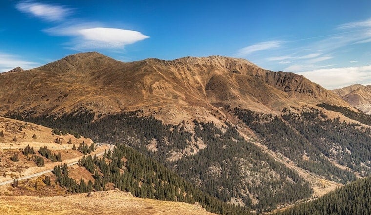
Fieldwork at Independence Pass
To ground those ideas in real terrain, the Aspen Global Change Institute ran a concentrated field effort on Independence Pass from July 14 to 17, 2025. The campaign relied on a mix of fixed sensors and handheld probes, with crews collecting hundreds of measurements each day across the steep alpine landscape.
As detailed by Aspen Global Change Institute, the team zeroed in on what they call “slope granularity,” that messy reality where one hillside can swing from soggy to bone-dry over a short distance thanks to aspect, shade, and vegetation. The goal is to figure out how well a single monitoring station represents the broader watershed and how those point measurements can be safely scaled up for planning across entire valleys.
Networks, Data Gaps and the Cost of Staying Wired
Where dense monitoring networks are in place, the payoff is already clear. The Oklahoma Mesonet, for example, operates about 120 stations that churn out soil moisture products roughly every 30 minutes, giving officials a near-real-time, statewide snapshot. That kind of coverage is the gold standard for what continuous soil monitoring can look like in practice.
The West, though, is still a patchwork. Some basins are wired up with modern sensors, while neighboring valleys are virtual blind spots. Platforms that gather all those feeds into one place are still relatively new. Colorado's IN-RICHES program and its Quench platform aim to knit together university, federal, and local datasets so managers do not have to chase numbers across half a dozen websites.
There is a catch. Building and maintaining buried sensor networks is not cheap. Each station needs equipment, installation, and ongoing care, and the data infrastructure has to be kept current. That is why template programs and steady grant support are central to any effort to expand soil monitoring across the region, instead of leaving it as a handful of pilot projects.
Local Managers Plug Soil Sensors Into Fire Planning
On the Roaring Fork and in Garfield County, watershed groups and fire collaboratives are not waiting for a perfect system. They are already pulling together soil sensor feeds, rain gauge data, and satellite products into public dashboards that help guide decisions on post-fire flood risks and wildfire mitigation priorities.
The Middle Colorado Watershed Council hosts one of those portals, with its data dashboard showing how soil moisture, rainfall, and other indicators feed into restoration work and defensible-space planning along the Middle Colorado River corridor. For residents and local officials, it is a way to see how the invisible underground conditions are shaping very visible choices about which areas get attention first.
Powerful New Tool, Not a Wildfire Crystal Ball
Researchers are quick to note that soil moisture is not going to call every shot. Sensors only reveal what is happening in a single soil column, and alpine terrain is notoriously fickle. A shaded north-facing pocket can look very different from a sunbaked south-facing slope just a short distance away, even on the same day.
Field teams and modelers say that is exactly why this technology is best treated as one more layer in a broader toolkit. It can improve forecast skill and offer early signals of when landscapes are primed for big fire days, but it is not a replacement for traditional weather monitoring or fuels assessments. Both the Independence Pass campaign and Holden's modeling work underline that soil data works best alongside those existing metrics, not instead of them.
As Colorado moves into a season that federal outlooks flag as having elevated potential for large fires on both the West Slope and the Front Range, managers are hustling to connect more sensors to platforms like Quench and to lock in funding that will keep those networks running. Whether that investment translates into measurably safer fire seasons will hinge on how quickly the data scales up and how willing incident planners are to fold soil-driven insights into daily decisions. For now, soil moisture is a promising, increasingly visible tool, but not an overnight fix for the region's wildfire worries.


