New York City is wiring up its streets in a big way, planting high-tech sensors on poles across all five boroughs to watch how people actually move through the city. The Department of Transportation says the expanding network, on track to hit about 100 locations, will turn scattered manual head counts into a steady stream of data that can drive quicker and safer street redesigns.
DOT Announces Citywide Rollout
In a June 2 press release, the New York City Department of Transportation said it will install sensors at roughly 80 more locations, bringing the total to about 100 sites citywide. According to NYC DOT, Commissioner Mike Flynn put it bluntly: “Safer street design starts with understanding what is actually happening on the street.”
The agency is pitching the move as a way to sharpen its safety playbook. By expanding a 2023 pilot, DOT says it can rely on continuous counts instead of short-term surveys, and use that richer picture of traffic patterns to speed up data-driven projects.
How The Sensors Work
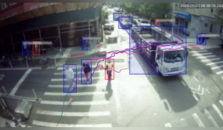
The devices are small boxes that look a lot like cameras, but their job is to quietly tally the chaos. Using on-device computer vision, the sensors can count different modes of travel, track paths through an intersection, and flag near-miss conflicts that never show up in official crash reports.
As described by VivaCity, the technology measures speeds, turning movements and “desire lines” that show where people actually want to go, even when the street design suggests otherwise. Video is processed at the edge, so raw footage is not retained. That always-on approach is meant to replace brief manual counts and capture weekday rush hours, late-night lulls and seasonal shifts that old-school clipboards would miss.
Privacy And Protections
City officials insist the system is built with privacy in mind. According to the agency, video is processed on each device, then the frames are discarded. Faces and license plates are blurred before any remaining information is turned into anonymous outputs.
The 2023 pilot documentation also says the City owns those anonymized outputs and planned to publish datasets through NYC Open Data at the end of the trial, according to NYC DOT. Officials argue that structure lets engineers dig into near-miss hot spots and desire-line maps without exposing personal details.
Who Gets The Data?
Advocates say the big question now is not just what the sensors see, but who gets to look over their digital shoulder. Gothamist reports that DOT does not plan to publish the raw datasets from the wider rollout.
During the 2023 pilot, inspectors conducted old-fashioned counts alongside the machines to check accuracy. Even so, transit advocate Jon Orcutt told Gothamist that keeping the data locked up would be a mistake and argued that taxpayers deserve regular, public reporting on what their sensors are seeing. The agency also declined to say how much the program will cost, Gothamist noted.
What Experts Say
Inside the agency, some planners sound genuinely excited about the new feed of information. Eric Beaton, NYC DOT's deputy commissioner for transportation planning, told Gothamist that “these sensors provide a much richer set of data for us to work with.”
Veteran traffic engineer Sam Schwartz pointed to the sensors' ability to operate 24/7 and spotlight problems that a few hours of manual counting might never catch. Their comments underline how much planning power this technology can unlock if New Yorkers are comfortable with the privacy protections and data access rules that come with it.
What To Watch
Next up, all eyes are on where DOT bolts the first new sensors to poles and whether the agency commits to a regular schedule of public reports based on the anonymized results. The placement map will say a lot about which streets the City sees as most in need of scrutiny.
If the rollout consistently shows heavy mid-block crossings, hidden bike routes or bus corridors that are begging for priority, the numbers could fuel faster safety redesigns and bus upgrades across the city. For now, officials say the sensors will help them target fixes more precisely, while community groups keep pressing for clarity on how much of the data will be shared outside City Hall.


