Honolulu has launched a new online map that pulls back the curtain on some of Oʻahu’s biggest natural dangers, from tsunami evacuation zones and FEMA floodplains to dam evacuation areas and wildfire risk. The Oahu Hazard Explorer lets residents drop a pin or plug in an address to see color‑coded hazard layers and plain‑language guidance tied to that exact spot, with city officials saying the goal is to help families, renters and small businesses fold local risk into their emergency plans.
City leaders rolled out the tool at a press conference earlier in the week, where Departmexnt of Emergency Management staff walked through the search bar and pin‑drop features, as reported by Hawaii News Now. DEM public information officer Molly Pierce told the station the site "specifies in which cases you would evacuate," and the debut came with simplified wording meant to help residents quickly understand what to do when alerts go out. According to the station’s report, the tool stitches together several official maps into one place so users are not bouncing between separate government portals.
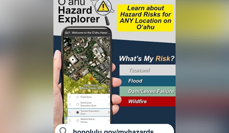
What the explorer shows
According to the City & County of Honolulu, the map brings together tsunami evacuation boundaries, FEMA flood zones, dam and levee evacuation areas, and a wildfire‑risk‑to‑homes layer so people can see, at a glance, which hazards touch their parcel or neighborhood. The site also includes straightforward explanations of each map layer and links out to preparedness resources that match the level of risk, per the City & County of Honolulu's Hazard Explorer page.
Why it matters this season
Forecasters say the 2026 season could feature more tropical activity than usual in the central Pacific, making clear hazard information especially timely, according to NOAA's Climate Prediction Center. NOAA’s outlook calls for a likely above‑normal central Pacific season, with roughly five to 13 combined named storms and tropical depressions, and officials emphasize that "it only takes one hurricane (or tropical storm) to cause a disaster."
How to use the map
To check a location, users can type or paste an address into the search bar or drop a pin on the map, then read the color legend to see whether that spot falls inside a tsunami evacuation zone, a floodplain, a dam evacuation area or an area with elevated wildfire risk to homes, as reported by Hawaii News Now. Officials recommend saving or screenshotting the evacuation instructions and folding that information into family and workplace disaster plans, while still relying on real‑time official alerts such as HNL Alert and National Weather Service updates during an actual emergency.
Officials and next steps
Oahu Emergency Mgmt. sent out an HNL Alert linking to the new Hazard Explorer and urged island residents to sign up for city notifications and revisit their evacuation plans. City staff say the map will be updated and refined over time, and are encouraging people to explore the tool before the central Pacific hurricane season hits its peak.


