Charlotte and much of the Piedmont landed squarely in the crosshairs today, as emergency managers in North Carolina expanded a midday severe weather outlook to a Level 2 (out of 5) threat and bumped up the tornado concern for central parts of the state.
⚡️Mid-Day Haz WX Update⚡️
— NC Emergency Management (@NC_Emergency) June 18, 2026
⛈️Since this AM,- Level 2 Severe Threat has been expanded across piedmont and the CLT area of the state.
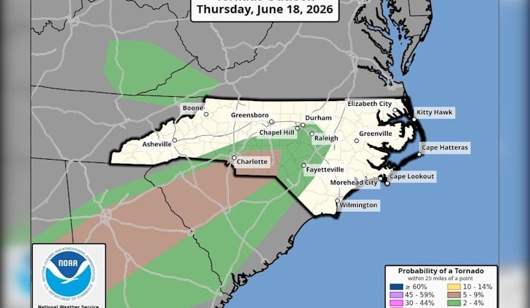
🌪️Risk for tornadoes expanded for much of central NC with the highest risk (5-9% which is brown in the graphic) around the CLT area.
#ReadyNC https://x.com/i/status/2067677301857271943
In a midday update on X, NC Emergency Management said the Level 2 severe threat had been expanded “across piedmont and the CLT area” and that the tornado risk now covers much of central North Carolina. The agency shared a graphic showing the highest short-range tornado odds, about a 5 to 9 percent chance within 25 miles, centered near the Charlotte metro.
What the outlook says
According to the National Weather Service’s Storm Prediction Center Day 1 Convective Outlook, clusters of thunderstorms could fire up this afternoon and continue into the night as a remnant circulation tracks northeast across the Southeast. Forecasters say there is enough low-level moisture and strengthening low-level shear to support damaging wind gusts, hail, and a few brief tornadoes.
Who’s in the line
The midday graphic and outlook place much of the Piedmont under the severe threat this evening. Officials listed sample towns across the state, from the mountains to the coastal plain, to show how broad the risk is. In practical terms, communities along the I-77 and I-85 corridors into the Triangle are being urged to stay alert for watches and warnings.
How to stay ready
Emergency managers are pushing a familiar message: have more than one way to receive alerts and know your safe spot before storms ramp up. The National Weather Service advises moving to a small interior room on the lowest floor away from windows if a tornado warning is issued, and keeping a battery-powered radio or phone alerts handy. Full details are available in the NWS tornado safety guidance. Local NWS offices and county emergency management pages will carry county-level watches and warnings through the evening.


