

























































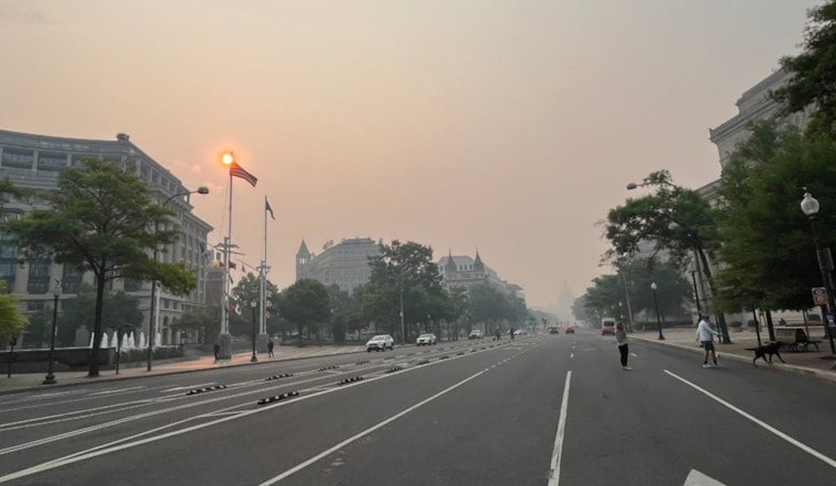
Washington rolled into Friday under a gray, hazy lid of smoke, with visibility knocked down as wildfire haze drifted in from the north. A Code Red air-quality alert is posted for the District and much of the metro region through midnight Saturday (July 18), making outdoor exertion a bad idea for just about everyone. Highs climb into the low 90s today, with an even hotter and stormier setup on Saturday that could unleash damaging winds and heavy downpours.
Air Quality and Health
The Metropolitan Washington Council of Governments has declared a Code Red forecast for Friday, warning that smoke and elevated particle levels will push air quality into the unhealthy range across much of the region. According to the Metropolitan Washington Council of Governments, children, older adults, and people with lung or heart conditions should limit time outdoors and skip strenuous activity. If you rely on inhalers or supplemental oxygen, shift plans indoors or to an air-conditioned space and keep an eye on local updates.
Severe Storm Risk Saturday
A strong cold front arriving Saturday (July 18) is poised to fire off multiple rounds of showers and thunderstorms, and the National Weather Service warns that a line of storms could bring damaging winds and localized heavy rain. The National Weather Service Baltimore/Washington highlights a high chance of storms from Saturday afternoon into the evening, with heat index values likely pushing into the low 100s ahead of the front. Some storms may move slowly at times, raising the odds of brief urban flooding in poor-drainage neighborhoods, so have a shelter plan ready and steer clear of standing water on roadways.
Today and the Commute
Through Friday, look for smoky conditions and mostly sunny skies, with highs near 92°F and light north winds. In the thickest haze, visibility could dip to a mile or two, including during the morning commute. The smoke has already cut visibility at area airports and surface observation sites, so drivers and transit riders should build in extra travel time and take it easy on outdoor portions of the trip. Organizers of outdoor events should consider moving indoors or delaying until air quality improves.
Boaters and Tidal Concerns
Increasing southerly flow Saturday, and again next Tuesday, could nudge water levels close to minor flood thresholds in some locations, especially around Annapolis. Waterfront users should keep tabs on local tide gauges and advisories. Small craft advisories may be needed Saturday, so if you plan to be out on the water, watch for rapid changes and be ready to head for safe harbor.
What To Do
For now, treat it as a two-day indoor game plan: limit strenuous outdoor activity today and Saturday morning, keep medications close, and check on neighbors who may not have reliable cooling. For severe weather safety, make sure you have a way to receive local alerts, bring a mask if you must be outside in the thick smoke, and never drive through standing water after storms roll through.





