Austin residents are soaking up unseasonably warm weather today, but meteorologists are casting their eyes towards a storm front that could give way to hazardous conditions by the weekend. Today's forecast predicts mostly sunny skies with temperatures hovering around a comfortable 74 degrees, which is a striking 10 degrees above the norm for this time of year, according to the National Weather Service.
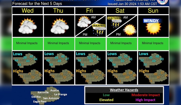
If you enjoy highs right around or a bit above 70 degrees, today's your day. High clouds this morning will gradually decrease into the afternoon. A few more dry & mild days before a system moves across the area Friday into Saturday bringing chances for showers and thunderstorms. pic.twitter.com/OnMkY6gEQi
— NWS Austin/San Antonio (@NWSSanAntonio) January 30, 2024
Even as the city enjoys a balmy reprieve, a fog advisory is in place for the early hours of Wednesday morning, mainly targeting Lavaca, DeWitt, and Karnes counties with potential visibilities dropping to a quarter mile or less. With the weather disturbance expected to swoop in by Friday night, local authorities are wary, given that ground conditions are still saturated from previous downpours, "Heavy rain possible later this week," warned a statement obtained by KXAN.
The upcoming disturbance, stemming from the Eastern Pacific, is slated to hit Texas, bringing with it heavy rainfall late Friday into Saturday. Forecasts project anywhere from half an inch to two inches of precipitation, with a 90% chance of showers and possibly thunderstorms on Friday night alone. "Rainfall totals are trending anywhere from 0.5\"-2\"... areas east of I-35 could see some nuisance flooding," especially since the soils are already primed with residual moisture from previous weather activity, as per KXAN.
El Niño's impact is undeniable this winter, with Austin reaching the fifth wettest January on record at Camp Mabry, accumulating a total of 6.07 inches of rain. Even with a likely wetter than normal February ahead, Austin has already exceeded average winter rainfall totals, a stark reminder that even amidst the easing point of a climate pattern, the payout can exact sudden downpours. "We have already registered 8.49" since December 1 in Austin," they indicated, exceeding the typical winter rainfall average, as reported by KXAN.
As Austinites navigate the oscillation between pleasant warmth and the looming threat of storms, residents and emergency personnel alike are urged to remain vigilant. Although the immediate forecast remains calm and clear, sustaining the notion of a city bathed in quiet sunlight, preparations for the impending weather disruption are advised, with the National Weather Service stating that "Spotter activation is not anticipated," guiding residents to heed potential weather advisories as the week progresses.


