Commuters in Austin are advised to tread lightly as dense fog blankets the area this Thursday morning, with the National Weather Service issuing a Dense Fog Advisory effective until 10 AM for the Hill Country and surrounding regions. Reports from NWS state visibility may drop to a mere quarter-mile, creating treacherous driving conditions and prompting officials to remind drivers, "Turn Around, Don’t Drown!" in case of flooded roadways.
While today's skies will clear later, leading to a partly sunny day with highs nearing 64, the potential for areas of fog re-emerges after 4 AM Friday, an unwelcome guest for early-risers, and in the wake of recent flooding concerns, Fayette County along with parts of Bastrop, Lee, and Caldwell County remain on alert under a Flood Warning according to KXAN. However, some relief comes as the Colorado River retreats below flood stage in La Grange, allowing for the cancellation of the river flood warning.
Dense Fog can be expected for the Hill Country, Edwards Plateau, and Rio Grande Plains through mid-morning. We should get some much-needed sunshine this afternoon as the fog thins out. Temperatures will be quite comfortable, in the 60s to lower 70s. pic.twitter.com/umiLYA7wmU
— NWS Austin/San Antonio (@NWSSanAntonio) January 25, 2024
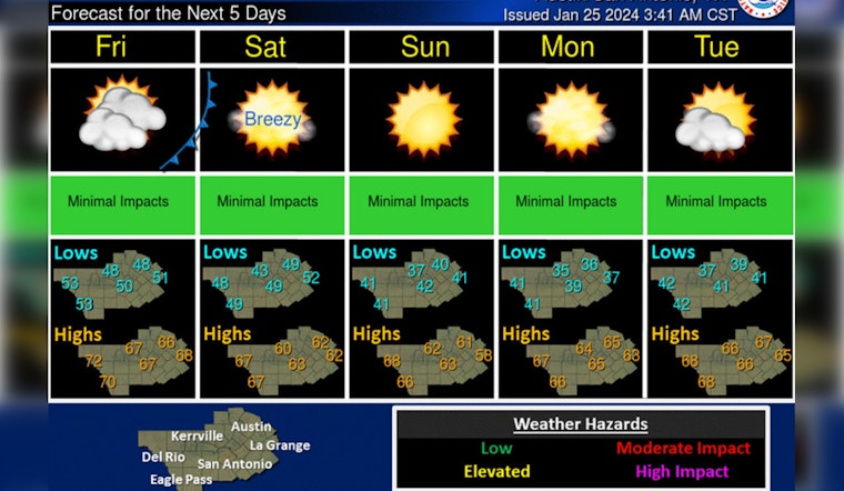
Looking ahead, the weekend forecasts from Weather.gov promise a sunny reprieve with temperatures residing comfortably in the low 60s Saturday and Sunday, cooling nights are expected with lows dipping just above the 40-degree mark making for crisp evening air, but no hazardous weather is expected after today's advisory subsides.
As the new week begins, meteorologists predict a mostly sunny sky with the thermometer ticking up slightly to a high near 65 on Monday and rising further towards the upper 60s as the week progresses, according to the NWS forecast.


