After weeks of unpredictable weather conditions, Houstonians can look forward to a stretch of stability as the forecast finally stabilizes. According to the National Weather Service, today's weather will see mostly cloudy skies, with a high near 59 degrees and northwest winds gusting up to 25 mph.
Tonight's temperatures are expected to dip to a low around 43, with steady northwest winds. The NWS Storm Prediction Center out of Norman, OK, has confirmed that "no severe thunderstorm areas forecast" for Sunday, providing locals with some peace of mind. The storm outlook reports, "Severe thunderstorms are not forecast on Sunday," providing a sigh of relief after recent tumultuous weather patterns.
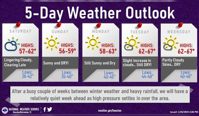
After a busy couple of weeks between winter weather and heavy rainfall, we will have a relatively quiet week ahead as high pressure settles in over the area.☀️☀️
— NWS Houston (@NWSHouston) January 27, 2024
Afternoon highs will be in the mid/upper 50s to mid-60s and cool overnight lows in the mid-30s to 40s.#HOUwx #TXwx pic.twitter.com/3w7SKYLC7A
Extending through the week, Houston will bask in sunny conditions, with daytime highs remaining consistently in the upper 50s to mid-60s. Evening temperatures will cool off to lows in the mid-30s to 40s. As the sun settles in over the area, a series of mostly sunny to partly cloudy days are lined up, with the next likelihood of any precipitation seeming a distant concern, as posted by the National Weather Service in Houston on their social media account.
As we head towards the end of the week, the forecast continues to play it mildly. "Thursday partly sunny, with a high near 65," while "Friday partly sunny, with a high near 67," according to the local forecast which Houstonians received with open arms and minimal need for umbrellas. With high pressure squarely in control, the weather narrative in Houston shapes up to be refreshingly free of drama, providing a placid backdrop for the business and buzz of the city.


