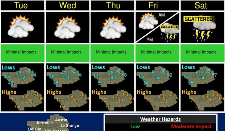
Austin residents can enjoy a burst of spring-like warmth this week, with high temperatures expected to stay firmly in the low 70s until a dramatic shift at the week's end. Today's sunshine comes with a comfortable high near 71 degrees, turning to a partly sunny Tuesday with similar temperatures. The trend of mild weather and more clouds continues through Wednesday and Thursday, according to the National Weather Service.
Another afternoon with highs in the upper 60s to low 70s is expected today. Skies will be mostly sunny with some high clouds present. Dry weather continues through Friday before a system moves across the area Friday night into Saturday. #txwx pic.twitter.com/nVmf7LkBl8
— NWS Austin/San Antonio (@NWSSanAntonio) January 29, 2024
Friday brings a notable change in pattern, with clouds building up and temperatures still hovering around 70 degrees, however, by nightfall, a 70% chance of showers looms. The city anticipates that conditions could take a turn for the worse by Saturday, with heavy rain and potential thunderstorms drenching the region. The risk of flooding is a real concern, as a quick-hitting Pacific storm could dump between 0.75" and 2" of rain across Central Texas, and possibly more in isolated areas, as reported by KXAN.
The weekend’s inclement weather may disrupt outdoor plans, with an 80% chance of showers and thunderstorms on Saturday set to bring highs down to the mid-60s. But those hoping for clearer skies should find some reprieve by Sunday, as the forecast calls for a mostly sunny day with cooler temperatures gracing the high 50s.
Austin residents are urged to stay informed on weather updates as the First Warning Weather Team continues to refine the forecast, indicating that, the late-week rain may offer a brief respite from the unprecedented stretch of mild weather. A 30 percent chance of showers Saturday night could lead into clearer skies, wrapping up the weekend with a nod to normalcy for this time of year, as per the National Weather Service.


