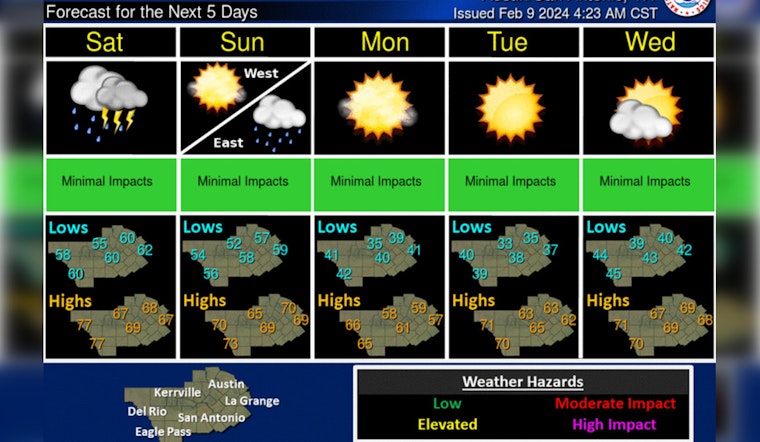
Austinites can expect a soggy weekend with multiple chances of storms, according to the latest weather forecasts. The National Weather Service reports that today will see patchy fog before 11 a.m., followed by cloudy skies with a high near 75 degrees. Winds from the south-southwest will range from 5 to 10 mph.
Tonight, the odds of showers increase, particularly after 3 a.m., with a 30 percent chance of precipitation and a low of around 60 degrees. The weather is set to take a turn on Saturday, with an 80 percent chance of showers and possibly a thunderstorm. There will be light, variable winds shifting to the northeast at 5 to 10 mph, coupled with new rainfall amounts that could fall between a quarter and half an inch.
Today cloudy and warm with some patchy AM fog. High temps from the low 70s to 80. Saturday and Sunday chance for showers and iso t-storms, rain amounts generally below 3/4 of an inch through the weekend. Monday through Wednesday will be dry again with cooler temperatures. pic.twitter.com/cbHZD1biyU
— NWS Austin/San Antonio (@NWSSanAntonio) February 9, 2024
In a statement obtained by KXAN, meteorologists have highlighted two main storm surges for the weekend. The first will see scattered showers and thunderstorms originating in the Hill Country before dawn on Saturday and pushing east towards Austin by late morning or mid-afternoon. The storm system bears a slight risk, classified as 1 out of 5, with the potential for hail, gusty winds, and an isolated tornado threat.
The second wave of storms is expected early Sunday, which promises to be a quicker and less intense episode of wet weather. By Sunday night, the skies should clear, leading to a breezy evening with a low of around 40 degrees. North northwest winds of 15 to 25 mph, could gust as high as 35 mph, turning an otherwise serene night into a bristling prelude to a sunny Monday with highs near 59 degrees.
Looking ahead to the new week, the forecast calls for sunny skies and a gentle rise in temperatures, eventually reaching the high 60s by Wednesday. Nights will remain mostly clear, with temperatures dipping to the low 40s. This brief intermission of calm weather precedes what forecasters warn could be a plunge back into colder, drier conditions with potential rural freezes on the horizon.


