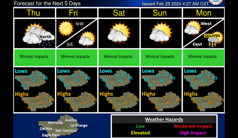
The bustling city of Austin is bracing for a surge of balmy air, but only after a cold front has brought gusty winds and a significant drop in temperature today. According to the National Weather Service, "Mostly cloudy, with a steady temperature around 55," Austin will see a north wind blowing between 15 to 20 mph, with gale forces reaching as high as 35 mph.
KXAN reports a sharp transition as the cold front swiftly moves across Central Texas, causing the mercury to struggle to rise above 50s, a stark contrast to the near 30-degree warmer temperatures experienced earlier in the week. To push back against the chill, northerly winds are expected to quickly reach sustained speeds of 20-35 mph, with gusts that could potentially rise to 45 mph, prompting a Wind Advisory effective until 4 p.m. today.
A cold front moving through the area this morning will bring cooler temperatures, strong northerly winds, and a near-critical fire weather threat through the day today. #txwx pic.twitter.com/ZbeWevkGs3
— NWS Austin/San Antonio (@NWSSanAntonio) February 28, 2024
While light precipitation may occur, don't expect any significant rainfall — "light sprinkles here and there won’t add up to much for most areas," says KXAN, projecting only up to 0.1"-0.25" of rain possible for some. Tonight, the forecast by the National Weather Service calls for continued cloudiness, with lows skirting the high 40s and winds gusting to a milder 25 mph.
Relief from this brisk spell is set to rapidly materialize by Friday. Austinites can to look forward to a sunny Friday with a high near a comfortable 75 degrees, and the spring warmth will persist through the weekend, perfect for any outdoor plans. These mild conditions should hold steadily into next week, with the National Weather Service predicting highs in the low 80s and a looming chance for showers and thunderstorms by Monday.


