The city's weather landscape is going for a cold spell this weekend as north winds bite and temperatures dip. The National Weather Service forecasts today a mostly sunny stride toward a high near 49, a sharp drop from the normal high of 67°. Tonight, thermometers are predicted to crash to a low around 32 with north wind gusts reaching up to 20 mph.
For anyone with marathon plans for the weekend, expect a kickoff in the low 30s. "Tomorrow's Austin Marathon will start with temperatures in the low 30s," KXAN reported. The crosswind, while less fierce than today's, will persist out of the north at a calmer sub-10 mph breeze. The upside: a sunny sky to soften the cold's sting. The subsequent shift from northerly to southerly winds Sunday night is the starting pistol for a warm-up, with temperatures climbing into the upper 60s for Presidents' Day.
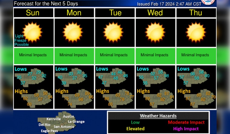
The weekend will be cold, and gusty winds will make for some wind chills in the 20s and 30s today. After a light freeze is possible tonight, a warming trend resumes as sunshine is abundant. Well above normal temps in the upper 70s and 80s is forecast Tuesday through Thursday. pic.twitter.com/2kicDpU2BX
— NWS Austin/San Antonio (@NWSSanAntonio) February 17, 2024
Yet, the hazards extend beyond the dip in the mercury. The Hazardous Weather Outlook warns of winds today cranking up to 25 mph with gusts roaring at 40 mph. Tonight, shivers travel deeper into Central Texas, forecasting an uppercut of "a freeze with low temperatures in the upper 20s to near 32 tonight into early Sunday morning," according to the weather service.
Thursday promises to fan the flames of caution with strong west to northwesterly winds paired with low humidities, conditions ripe for wildfire ignition "especially over the Hill Country, Edwards Plateau, and Rio Grande Plains," according to the weather service. Consoling residents, the forecast serves as a soft landing to the frigid episode with highs gently falling from the sunny summits of low 80s midweek to embrace the mid/upper 60s to around 70° by Friday's end.
In the longer forecast, rain remains a spectator to Austin's weather scene for the coming week. The parched Hill Country, however, may steel itself for more thirst as KXAN notes, citing the Climate Prediction Center, "much of the area...to have below normal precipitation" as the calendar crosses from February into March. Above-normal temperatures will keep company with the dry spell, clinging to the upper 60s for highs and upper 40s for lows—solid numbers pegged to warm some spirits in a week where the cold has been all too real.


