Austin residents woke up to a stormy start this Sunday, but the skies are expected to clear up just in time for Super Bowl afternoon fun. According to the National Weather Service's forecast, there was a 50 percent chance of showers and thunderstorms before 10 a.m., with some storms potentially being severe. Before the clouds parted, the area was shrouded in areas of fog, leading to poor visibility on the roads.
As per a warning by the National Weather Service, a Hazardous Weather Outlook was issued for South-Central Texas including the Hill Country, where very large hail and damaging winds could have potentially accompanied the final round of thunderstorms after midnight. A low possibility for severe storms extended through Sunday morning in areas near and east of I-35 and mainly north of I-10. Additionally, the outlook cautioned about near-critical fire weather conditions along the Rio Grande late on Sunday.
With the addition of the new severe thunderstorm watch, we have cancelled the existing watch in Val Verde, Dimmitt, and Uvalde County. The counties currently in a watch are in pink. Counties will continue to be cleared as the threat moves from west to east through the morning. pic.twitter.com/bY5j0KfyNO
— NWS Austin/San Antonio (@NWSSanAntonio) February 11, 2024
In the KVUE's latest weather report, the morning's thunderstorms, which potentially carried large hail and gusty winds, have already pounded the region's Hill Country. These early disturbances were expected to march eastwards throughout the morning with the possibility of slightly weakening before reaching the I-35 corridor.
Coming with the expected clearing in the afternoon, breezy conditions with northwest winds between 10 to 15 mph, and gusts as high as 25 mph have settled over the city. As the nighttime comes around, the skies will remain mostly clear with a low dipping to around 41 degrees. The winds are sticking around even as the sun sets, blowing northwest at 10 to 20 mph, and gusts peaking at about 30 mph.
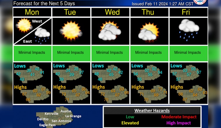
Looking ahead, Austin residents can enjoy sunny skies through to Valentine's Day with a gradual warm-up in temperatures. However, Rainy weather is predicted to make a comeback Thursday night, with a 40 percent chance of showers. And always looking to the horizon, chances of precipitation climb to 70 percent by Friday, providing a significant contrast to the earlier half of the week's serene weather.


