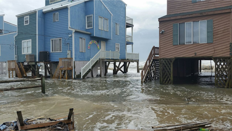
The National Weather Service in San Francisco has issued multiple warnings affecting the Bay Area, including a Beach Hazards Statement due to increased risks of sneaker waves at area beaches through 4 am Wednesday, as per their announcement on X. Additionally, residents are alerted to a Coastal Flood Advisory in place through Saturday, spurred by high astronomical tides that could lead to minor coastal flooding, according to information from the NWS Forecast Office.
Good morning! A Beach Hazards Statement is in effect now through 4am Wednesday. Long period and larger swell has brought an increased risk of sneaker waves to area beaches.
— NWS Bay Area 🌉 (@NWSBayArea) February 6, 2024
Additionally, a Coastal Flood Advisory is in effect through Saturday for high astronomical tides. #CAwx pic.twitter.com/3tmUvx5SVt
Residents near the San Francisco Bay and northern valleys have been advised that tidal levels could run up to 1.50 feet above normal, resulting in potential flooding from 6 AM to 10 AM daily as stated in a forecast discussion by the National Weather Service San Francisco CA. The currently stationary long-wave trough over the California coastline has generated conditions more akin to that of a cauldron, harboring both scattered showers and isolated thunderstorms mainly over the Central Coast, and these conditions are anticipated to continue into Wednesday with the arrival of another weak weather system."
The NWS is also considering a Beach Hazards Statement to encompass the entire coast from Sonoma County through Monterey County, effective until early Wednesday, with waters swelling in response to the persistent trough and brisk 500 mb heights and temperatures near Oakland expected to be cold but above the minimum moving average, the details of which were elucidated in the Area Forecast Discussion. The advisory covers the risk of sneaker waves, notoriously capable of catching beach-goers off guard. With breaking waves that may reach up to 10 feet, beach visitors are cautioned to exercise extreme vigilance around the ocean.
In terms of aviation, VFR conditions are predicted to continue for the majority of terminals with the exception of KSTS where MVFR conditions due to fog are expected to persist into the late morning operators and travelers should anticipate scattered showers through the region this morning, and moderate northwest winds below 10 knots that will increase and become gusty as early as Wednesday morning, impacting airport operations with gusts of 18-20 knots around San Francisco.
Mariners face a similar advisory with the NWS calling for light to moderate northwesterly winds throughout today, intensifying into Wednesday, scattered showers will span the coastal waters with the approach of widespread rain by Wednesday, as a long period northwest swell impacts the waters through the end of the week, this information obtained through the Marine Forecast, wherein the potential for a more weather pattern towards Presidents weekend was also highlighted, indicating a possible renewal of storms heading into late February and March.


