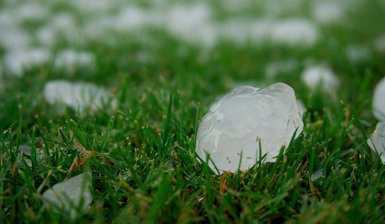
Central Texas woke up to a hammering as severe weather, including strong winds, a tornado warning, and notably large hail, pummeled the area early Sunday, KXAN reports. The harrowing conditions forced the National Weather Service to issue, then cancel, a tornado warning for Fayette County by 9:15 a.m.; the storm had moved on to assault Austin and Washington counties. Sky-high clumps of ice rained down in places like Belterra and West Point, where residents like Melinda Briggs caught the action on camera, snapping shots of hailstones dwarfing quarters. Theresa Ivey, another local, shared a picture of the sizable ice from Muldoon, southwest of Fayette County.
Meanwhile, the Texas Storm Chasers prepared adrenaline enthusiasts for a wild ride as they forecasted an impending once-in-a-decade snowstorm across the Texas Panhandle, West Texas, and buses will risk grinding to a halt due to thickening slush come Sunday night into the Monday morning commute, especially as temperatures dip below freezing, transforming wet surfaces into treacherous sheets of ice. This storm brings everything – potential thundersnow, heavy snowfall accumulations, and tricky travel conditions, not to mention the threat of significant tree and powerline damage in areas suffocated by over a foot of snow.
And the chaos doesn't stop there: severe thunderstorms are primed to unleash havoc elsewhere in the State of Texas, with hail the size of baseballs, damaging gusts, and even tornadoes stepping up to the plate overnight. The tempest is expected to extend its reach during the wee hours of Sunday, with Central Texas, the Hill Country, and South-Central cities like Waco and San Antonio squarely in its sights. As the storm system barrels eastward, the Ark-La-Tex, East Texas, the Brazos Valley, and Southeast Texas should brace for an encore of severe weather—complete with high-stakes hail, wind, and isolated tornado risks.
On top of the treacherous wintry mix and thunderous roars, heavy rainfall poised to reach totals of one to three inches could usher in localized flooding—creeks and streams are expected to swell, putting additional strain on already saturated watersheds, but it's not all doom and gloom, as temperatures are forecasted to rise, helping snow and slush to thaw by Monday afternoon after which temperatures will once again take a nosedive Monday night into Tuesday morning, which could set the stage for another icy dance. As residents and storm chasers alike bunker down, they can rest assured the return to more temperate February climes will be swift, with the 50s, 60s, and 70s heralding a sunnier outlook for the rest of the week, dry skies gracing the forecast promised by Texas Storm Chasers


