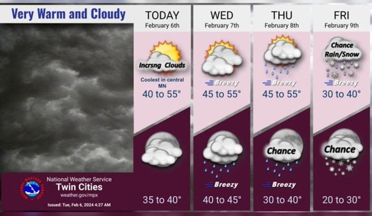
Minneapolis residents better keep their umbrellas handy and jackets zipped up tight as the city braces for a string of dreary weather conditions. According to the latest update from the National Weather Service, cloud cover is set to increase today with temperatures hovering around a comfortable 54 degrees. Those out in the South southwest will likely feel gusts between 5 to 15 mph.
As nightfall approaches, the skies over Minneapolis won’t be offering any celestial views, with mostly cloudy skies dominating and the mercury dropping to a gentle 40 degrees. The breeze will remain steady, coming from the South southeast at a mellow 5 to 10 mph pace. But don't get too comfortable; Wednesday is looking to stay on the cloudy side, with highs matching today's and winds picking up to 15 mph from the Southeast, according to forecast.weather.gov.
Wednesday evening plans might need to shift indoors as showers are likely to commence after 1 a.m., carrying on into a rainy Thursday. The expectation of 60% precipitation comes with the territory of a low near 44 degrees, while the wind refuses to calm down, potentially ramping up to gusts as high as 30 mph. Thursday will demand rain gear with an 80% chance of showers, so traffic and commutes may just take that turn for the worse.
Record warmth possible into Thursday as a storm system arrives after mid-week. Rain showers are expected Wednesday night and into Thursday. Precip chances continue thru Friday night as cold air turns light rain into light snow. #mnwx #wiwx pic.twitter.com/SADLFQkEcO
— NWS Twin Cities (@NWSTwinCities) February 6, 2024
The soggy situation is set to persist into Thursday night, with showers likely ending around 10 p.m., afterward, the city will likely see occasional rain until 1 a.m. The term “breezy” might be putting it lightly as gusts could reach up to unrelenting 30 mph, while temperatures should settle around a chilly 36 degrees. Those towards the weekend have a 40% chance of being confronted with the indecisiveness of a rain and snow mix, adding to the potential of slick roads and another reason to keep cozy indoors. Friday night continues the trend with a possibility of snow before 7 p.m. and lows around 28 degrees.
Minnesota won’t be waving goodbye to the clouds anytime soon, with predictions suggesting a mostly cloudy Saturday, though the temperatures will be dropping to a chillier high near 32 degrees. The cold snap isn’t showing any mercy as we move into the night, with lows expected at around 25 degrees. Sunday, while offering a glimpse of the sun, keeps the party cloudy at night and into Monday. With the Midwest well-versed in the temperament of its weather, residents will be holding on to hope for brighter skies ahead.


