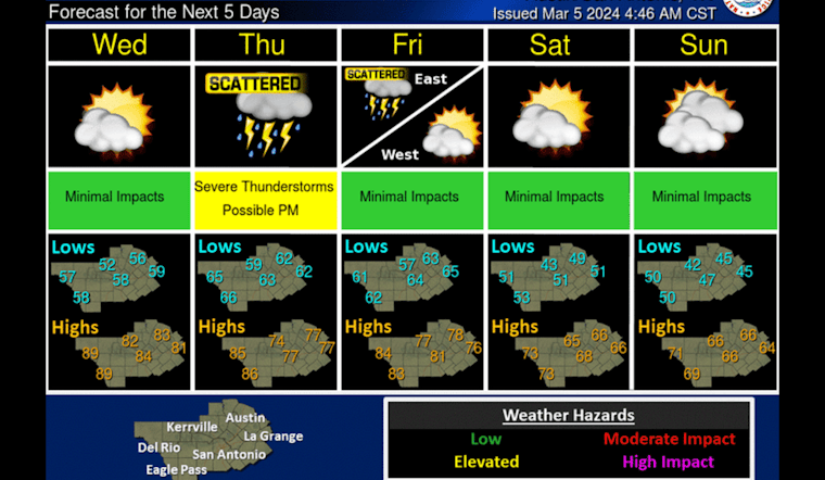
With mercury levels set to hit a scorcher today in Austin, residents are preparing for an intense wave of heat before storm clouds roll in to potentially dampen spirits towards the end of the week. The city is expected to bask in temperatures that rise to nearly 89 degrees, pushing the envelope some 20 degrees above the norm for this season, as reported by the National Weather Service.
Though the highs today will invite folks to shed their layers, Austinites should brace themselves to also take cover from a late-week tempest that could stir up a bit more than just a common downpour. Thursday and Thursday night are slated to bear the brunt of our precipitation prospects, according to KXAN. The local weather forecast suggests that the approaching cold front is likely to not only bring showers but also hammer out some severe storms.
Fog in the morning and then turning warm in the afternoon with highs in the 80s and even low 90s along the Rio Grande under mostly sunny to sunny skies. Next chance for showers and storms comes on Thursday evening into Friday. Cooler over the weekend. #txwx pic.twitter.com/g65xJx3B7c
— NWS Austin/San Antonio (@NWSSanAntonio) March 5, 2024
As the week progresses, the outlook calls for mixed conditions. Wednesday will cool down slightly with a high near 84 under partly sunny skies. But by Thursday, the city should expect a 40 percent chance of rain, setting the stage for what could be a wet and wild segue into the weekend. The chances of rain and thunderstorms climb to 50 percent the same night, with "cloudy" skies predicted by the National Weather Service.
Additionally, Austinites should plan to double-check their rain gear. "Our best chance for rain this week comes Thursday into Friday as a cold front approaches," warned KXAN. Rainfall estimates hover between .10 inches to half an inch across the affected days. Following Friday's deluge, temperatures are expected to pace themselves, with highs fluctuating from the 60s to low 70s over the weekend.
Residents will get some reprieve by Saturday, with a mostly sunny day but also with crisp northern gusts that could whip up to 30 mph. By the time Monday arrives, the city should see the sun in full swing and a high near a more temperate 72. Those looking forward to the cooler temperatures should note that Sunday morning is likely to nudge the mercury down to the low to mid-40s, as per National Weather Service data.


