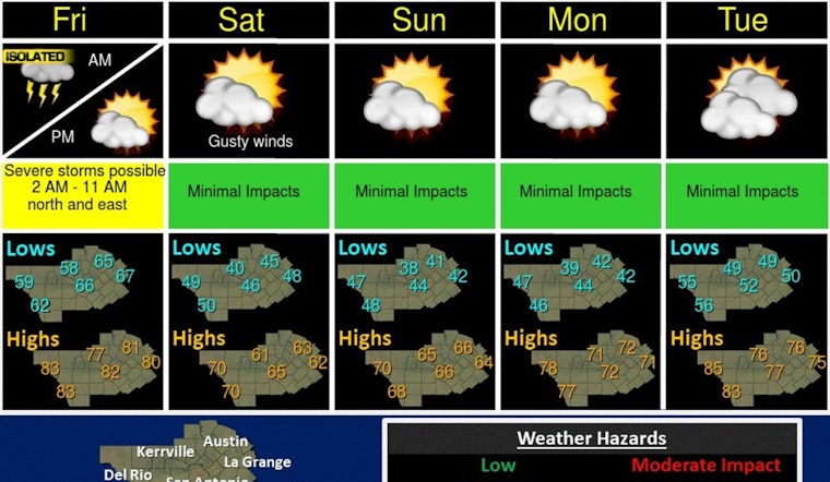
Austin residents, brace for a grab-bag of weather changes rolling in over the next few days. Today's forecast sees a 30 percent chance of rain with possible thunderstorms after 4 p.m., paired with high temperatures reaching near 75 degrees. Boisterous south-southeast winds are expected to pick up, gusting as high as 25 mph, according to the National Weather Service.
Some drizzle or light rain is possible this morning with showers and storms developing in the afternoon. Isolated strong to severe storms possible overnight into Friday morning. Cooler this weekend and warming next week. #txwx pic.twitter.com/NcvZxVAjLE
— NWS Austin/San Antonio (@NWSSanAntonio) March 7, 2024
Tonight's weather might quickly disrupt plans as there's a 40 percent chance of showers and thunderstorms into the evening. These could persist into Friday morning with a lingering 40 percent chance of precipitation before skies begin to clear up, leading to a sunny afternoon, noted the National Weather Service. As the weekend approaches, strong winds are set to usher in cooler air, dropping temperatures dramatically.
KXAN reports that despite today's milder forecast for the Austin Metro area, there's a marginal risk for severe storms, with a slightly higher likelihood in the Hill Country. Large hail could be part of any severe storm that develops, although damaging winds are less likely and the risks of flooding and tornado conditions are considered minimal.
Friday will see strong or severe storms likely pop up between 2-3 a.m. for folks in the Hill Country and hit the Austin metro area around 5-7 a.m. A cold front is set to quickly clear the air afterward, leading to a drop in temperature that will set the stage for a brisk weekend. Daytime highs aren't expected to climb out of the 60s, with the nightly low plummeting to the chilly 30s and 40s. Additionally, residents should remember to set their clocks forward one hour early Sunday morning as daylight saving time swings into effect.


