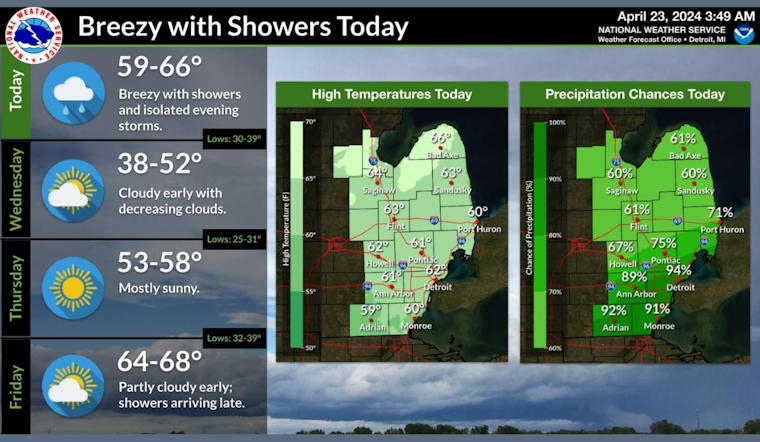
As Detroit braces for a wet and windy week, residents can expect showers and gusts reaching up to 31 mph today. The dismal weather is set to move in after 1 pm, with forecasters predicting a "high near 62" and a "chance of precipitation is 90%." Possible accumulations could range between "a tenth and quarter of an inch," indicating that the city should prepare for a noticeable amount of rainfall, according to the National Weather Service.
For those looking to enjoy a dry evening tonight, they might want to rethink their plans. The National Weather Service reports "showers likely before 2 am," with a low hovering around 39 degrees. Blustery conditions will persist as the southwest wind decreases to 10 to 14 mph, gusts topping a still-noticeable 23 mph. With a 60% probability, residents should keep their umbrellas at hand.
As we head into Wednesday, the skies are expected to clear gradually following a mostly cloudy start, promising some reprieve midweek with a high of near 50 degrees. However, the wind remains a steady presence, blowing from the north at 13 to 15 mph and gusting as high as 22 mph. The clear trend continues into Wednesday night, as temperatures dip to a chilly low of around 31 degrees amid a gentle north wind.
Looking ahead, Thursday promises more congenial weather, with the National Weather Service forecasting "sunny" conditions and a pleasant high creeping towards 57. Winds are set to be "light and variable" at dawn, before picking up slightly to 5 to 8 mph from the east-southeast during the morning hours. The nighttime chill returns, though less severe, with a "mostly clear" sky and a low around 40, suggesting Detroiters may enjoy a respite from the need to crank up their heating.
The week's weather narrative takes a positive turn by Friday as temperatures ascend to near 67 degrees beneath "mostly sunny" skies. Unfortunately, this break is short-lived; showers are slated to return Friday night, continuing through a balmy and "breezy" weekend. Highs will soar to the upper 70s by Saturday, but not without the dampening prospect of more rain "mainly before 2 pm" and again at night.
As the weekend wraps, Sunday won't shake off the wet weather, maintaining a high near 78 and breezy conditions that seem to serve as the week's persistent backdrop. Showers are on the docket again for Sunday night and into Monday, culminating in a week where the weather itself tells a story of transition - from placid sunlit moments to tempestuous, rain-laden chapters.


