Dallas residents are bracing for a wet and wild ride as the National Weather Service (NWS) issues a smorgasbord of weather alerts, including thunderstorms and flood warnings. The skies above Texas' third-largest city are expected to unleash showers and thunderstorms primarily before sunrise today, with new rainfall between a tenth and a quarter of an inch. However, weather wonks at the NWS suggest that higher amounts could fall amid heavier thunderstorms. The day's high should hit a humid 82 degrees, with winds swinging wildly from the south-southeast to north-northwest.
Under the cloak of night, Dallas might see a few more showers as there's a 20 percent chance of rain and thunder after 4 a.m. The wind is set to chill out tonight, going almost still after dancing the north-northeast earlier in the evening. And for those planning their Saturdays, a 30 percent chance of storms lingers mainly post-7 a.m., with temperatures climbing up to a near-balmy 88 degrees, according to the National Weather Service.
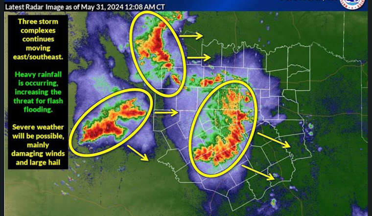
Joining the weather fray, a Hazardous Weather Outlook has been posted by the NWS, casting a wary eye on potential severe storms that may trundle across the region this morning into the early afternoon. The concern isn't just rain — damaging wind gusts and flash floods are very much on the table. Storm spotters might have to jump into action this morning in parts of the area as NWS-led vigilance continues through the next week.
As if on cue, powerful winds associated with decaying thunderstorms are rearing their heads, prompting a Special Weather Statement. Residents in parts of Rockwall, Kaufman, Wise, Denton, Tarrant, Collin, and Dallas Counties should watch for winds gusting between 40 and 50 MPH. These gusts could easily turn loose items into airborne hazards and break tree limbs. The statement includes specific timing for areas expected to be hit, punctuating the advisory with a call for the public to "consider seeking shelter inside a building," as reported by the Hazardous Weather Outlook.
Flood Warnings are another thread in this tapestry of alerts, with several rivers expected to swell beyond their banks. The Trinity River at Dallas, for instance, is already experiencing minor flooding and the NWS forecasts this will continue until tomorrow afternoon. Flood stages have been reached or exceeded with the weather service warning of agricultural and low-lying areas getting inundated. Such high water levels are somewhat routine for those who steward these lands, but that doesn't lessen the need for caution, particularly near flooded roadways and riverbanks.


