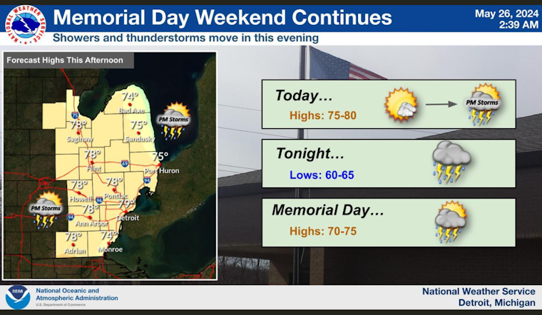
Residents of Detroit should brace themselves for a week of fickle weather ahead, as forecasted by the National Weather Service. Today's sun may give way to showers and storms after 5 pm, with temperatures approaching 79 degrees. A breezy southeast wind could carry gusts up to 18 mph. There's a 30% chance that rain will dampen the city, disrupting the largely sunny outlook, according to the National Weather Service.
The evening, looking wetter with an 80% chance of precipitation, is expected to bring potentially heavy rainfall, especially as thunderstorms might rumble through between 8 pm and 2 am. Residents, while enjoying the balmy low of 64, should prepare for southeast winds that might escalate quickly, gusting as high as 23 mph. Between a tenth and a quarter of an inch of rain could grace our yards, with the potential for higher amounts where thunderstorms decide to attend.
Memorial Day is looking rather indecisive, with a partly sunny sky interrupted by a 40% chance of showers and thunderstorms before 2 pm. Highs are anticipated to be near 75, while the south southwest wind may display its might, gusting at speeds reaching up to 28 mph. The evening promises clearer skies with a low around 59, under the steady push of a west wind moving at 10 to 15 mph.
Looking forward to Tuesday, folks might catch a brief respite from the rain in the morning. But showers are likely again after 2 pm, with a 60% chance that thunder will shake the mostly sunny skies. The temperature is predicted to soar to a respectable 73. Winds from the west may carry gusts reaching up to 23 mph, as they did before on Monday evening. It seems that the week's weather has a penchant for sudden gusts, teasing us with calm then challenging umbrellas in fierce bursts.


