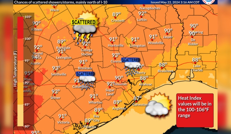
Houston residents can look forward to a slight and uncertain respite from the sizzling heat today with showers and possible thunderstorms predicted, primarily north of I-10. According to a forecast by the National Weather Service, the city might experience "A slight chance of showers between 10am and 1pm. Mostly cloudy, with a high near 90. Heat index values as high as 101. Southeast wind 5 to 15 mph, with gusts as high as 20 mph. Chance of precipitation is 20%."
Lingering into the night, "A slight chance of showers and thunderstorms between 10pm and 1am. Mostly cloudy, with a low around 78. Southeast wind 10 to 15 mph, with gusts as high as 20 mph. Chance of precipitation is 20%." This information was brought to the fore by the Weather Forecast Office in Houston.
A broader severe weather outlook was issued by the Storm Prediction Center, which indicates that "There is a slight risk of severe thunderstorms across portions of the Great Plains into the Mid-South" for tomorrow. The areas affected could see damaging gusts, hail, and a couple of tornadoes, with isolated strong to severe thunderstorms possible across the Ohio and Tennessee Valleys into the Mid-Atlantic and Northeast. The synopsis suggests enhanced airflow across the region that might contribute to the adverse weather conditions.
The local situation for Houston later this afternoon and into the evening leans toward storminess, with the potential for some of them to turn fierce. The National Weather Service outlook shared via their X feed highlights that the incoming line of storms may be strong to severe. As residents steel themselves for the heat of the day, they must also brace for the possibility of tumultuous weather, which, while it might grant some relief from the heat.
Slight chance of a brief relief from the heat in the form of showers/storms today mainly north of I-10. A line of storms is expected to move in from the north this later this afternoon/evening and some storms may be strong to severe. #TXwx #HOUwx #BCSwx #GLSwx pic.twitter.com/SPTQKdBcWw
— NWS Houston (@NWSHouston) May 22, 2024
Looking forward, Houston is slated to endure a mostly sunny Friday, with the mercury climbing up to a scorching 92 degrees, accompanied by gusts as robust as 20 mph. The weekend promises no escape from the heat, with temperatures expected to soar even higher and the highs pushing close to the mid-90s. The heatwave is set to peak on Memorial Day, with temperatures flirting with the mid-90s yet again.


