Houston residents are preparing for Memorial Day barbecues and celebrations are looking at a scorcher with potential for severe weather on the horizon. The National Weather Service (NWS) issued a detailed forecast, warning of a high near 97 degrees and a heat index rising to a sweltering 111 degrees. Although there's "a 20 percent chance of showers and thunderstorms" in the late afternoon, it's the heat that will be punished with southeast winds blowing at a mild 5 to 10 mph.
In addition to the heat, the NWS Houston has flagged multiple weather hazards for the area on Memorial Day. A Heat Advisory is in effect across all counties, and beachgoers should beware of "high risk of rip currents" along the coastline. NWS Houston didn't mince words about the potential for "isolated afternoon/evening thunderstorms," reminding Houstonians that they can't "rule out isolated severe thunderstorms."
Things aren't expected to cool off as the week progresses. Initiating Tuesday, a 20 percent chance of showers and thunderstorms persists with heat index values maintaining a viselike grip as high as 105 degrees. Come Wednesday, storm chances ramp up to 40 percent with partly sunny skies and highs hovering around 90 degrees. Thursday ups the ante with a 50 percent probability of showers and a modest decrease in the mercury to near 88 degrees, suggests NWS.
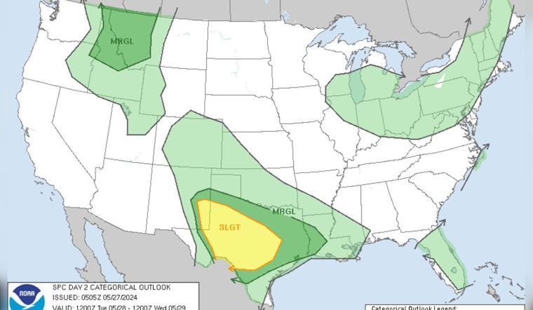
As residents move past Memorial Day, those living in the heart of Texas should keep an eye to the sky as "a slight risk of severe thunderstorms Tuesday into Tuesday night" spans across central and western Texas into southeastern New Mexico, according to the Storm Prediction Center. They're calling for a volatile mix of "strong thunderstorms, perhaps including a few supercells and a couple of organizing clusters posing a risk for severe wind and hail." The specifics paint a turbulent picture of weather patterns affected by a dance of troughs and ridges across the U.S., potentially intensifying convective systems that may sweep through the Texas landscape.
As night falls each evening, the likelihood of thunderstorms diminishes slightly, with forecasts showing a consistent 20 percent chance of rain and more manageable temperatures in the high 70s.


