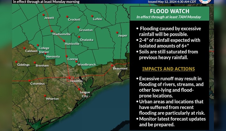
Houston residents are bracing themselves for a week of rough weather as forecasters predict a cocktail of heavy rain, severe storms, and potential flooding. The National Weather Service (NWS) in Houston has issued a flood watch for areas north of the metro, effective from this morning through at least tomorrow morning. As per the NWS Houston's X account, the city is bracing for "another opportunity for heavy rain and severe storms" starting today.
We've got another unsettled week of weather ahead of us, starting with another opportunity for heavy rain and severe storms beginning today, carrying into Monday. A flood watch north of the Houston metro begins this morning, and will be in place through at least Monday morning. pic.twitter.com/DUFCBeKC1o
— NWS Houston (@NWSHouston) May 12, 2024
The weather drama kicks off with a likelihood of showers and thunderstorms today, mainly after 1 p.m., under a veil of mostly cloudy skies, with a juicy high near 81 degrees — this according to Houston's Weather Forecast. However, the instability won't let up as the new week dawns; tomorrow is forecast to dish out another round of showers and thunderstorms, particularly between 1 p.m. and 4 p.m., then possibly continuing after 4 p.m.
Adding to the climatic tension, the Storm Prediction Center (SPC) has placed central and east Texas, including the Houston area, under a slight risk of severe thunderstorms for Monday. The SPC's Convective Outlook warns that severe thunderstorms are possible on Monday from central and east Texas into the Lower Mississippi Valley.
By the time Wednesday rolls around, Houstonians might catch a brief break with mostly sunny conditions forecasted, and highs flirting with the upper 80s. But the respite is short-lived—Thursday threatens more showers and thunderstorms, with an assertive 70 percent chance of precipitation haunting the area. While the weekend seems partly sunny, Saturday's forecast dangles a 20 percent chance of showers and thunderstorms, which, according to Houston's Weather Forecast, might add a final spit to a week marked by a tempestuous weather pattern.


