Austin residents can look forward to a mostly sunny skies today with temperatures peaking at 96 degrees and the heat index pushing the comfort envelope as high as 103, according to the National Weather Service. This marks a significant departure from the season's norm where the average high for June 16th typically sits at 94 degrees, while tonight's forecast promises a mostly clear sky and lows around 76.
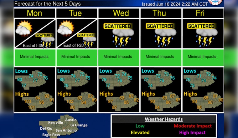
Beyond Father's Day celebrations, the weekly outlook points to a creeping uncertainty as the chance of showers and thunderstorms enters the picture, starting at a modest 20 percent on Monday but swelling to a 70 percent likelihood by midweek, during the period, the temperatures are expected to take a slight dip in response to the increased cloud cover and precipitation, this according to KXAN. This comes on the heels of the National Hurricane Center's update, which pointed to a developing system over Central America with a ten to sixty percent chance of tropical formation affecting the region's weather patterns within the next week.
The expected showers arriving Tuesday herald the beginning of a wetter streak, with a 50 percent chance of thunderstorms forecasted for Juneteenth, and the moisture set to intensify on Wednesday and Thursday. If the predictions hold true, Austinites could see rainfall totals between 1.50 to 2.50 inches over the next week providing much-needed relief after a particularly parched start to June that only accumulated a meager .23 inches of rain so far.
The outlook for the latter part of June continues to trend toward wet conditions, a forecast buttressed by the Climate Prediction Center which indicates that the month's final days could remain wetter than normal while Friday and Saturday are looking to heat up again with a return to the 90s, despite lonelier chances of rain, a reprieve from the soaking we might expect in the days prior.


