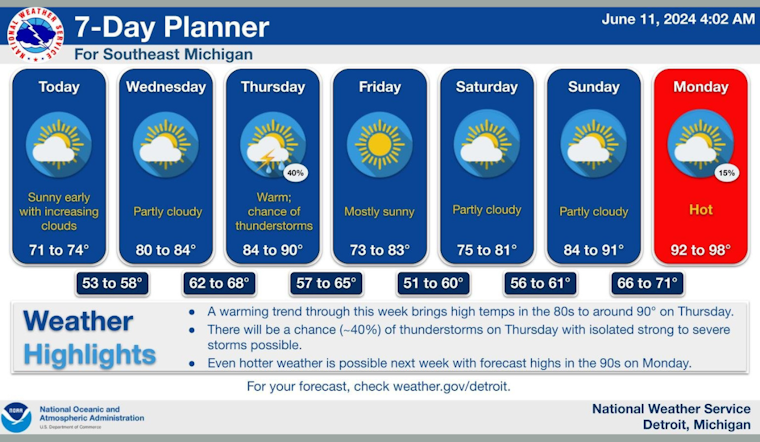
The city of Detroit should prepare for a blend of sunny skies and potential thunderstorms in the upcoming week, based on the most recent weather forecasts. Starting today, residents can enjoy clear skies with a comfortable high of 74 degrees, according to a forecast from the National Weather Service. Winds are expected to remain light, shifting southeast in the afternoon.
Tonight, a shift brings increasing clouds to the Detroit area, with temperature dipping to a low of around 59 degrees. Those clouds portend a mostly sunny Wednesday, with a rise in the mercury to a high near 84. The southwestern winds will maintain a gentle pace at 5 to 10 mph. Wednesday night's conditions look to stay partly cloudy with the low settling around 68 degrees.
Temperatures are predicted to climb as the week progresses, with Thursday heating up to near 90 degrees amid mostly sunny skies. The winds are slated to pick up as well, gusting as high as 26 mph. Nightfall on Thursday might bring the week’s first bout of showers and thunderstorms, particularly between 8 pm and 2 am, with the potential for continued rainfall into the early hours. Despite the 40% chance of precipitation, lows are expected to hover in the mid-60s.
Looking ahead to the weekend, Detroiters can anticipate a return to mostly sunny conditions with highs in the low 80s and overnight lows ranging from the high 50s to low 60s. Sunday will bring temperatures up again—nearing the 90-degree mark under mostly sunny skies. By Monday, the city gears up to embrace the full brunt of summer heat, with a "sunny and hot" day holding highs nearing a sweltering 96 degrees.


