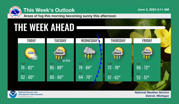
As Detroit residents wake up this morning, they can expect areas of fog hanging around until 11am before the day gradually clears up, according to the latest weather forecast. The city is heading for a comfortable high of about 80 degrees with a light southeast breeze in the afternoon.
Tonight, the city's sky will become increasingly cloudy, as the temperatures dip to a low near 66, with southeast winds continuing at a relaxed pace of 5 to 7 mph. Increasing clouds, Detroiters may need to grab an extra layer when they step out into the evening's gentle breeze.
A rise in temperature kicks off Tuesday as the forecast predicts a partly sunny sky with a high approaching 88 degrees, accompanied by a south wind traveling at 6 to 10 mph. Bird watchers on an early trek might be lucky to see a variety of species before the clouds set in at dusk.
Rains are on the horizon for the mid-week, with the National Weather Service indicating a 90% chance of showers and possibly thunderstorms Wednesday afternoon. Showers may bring a quarter to a half inch of new rainfall, with gusts hitting as much as 23 mph.
Following the mid-week downpours, Thursday provides a brief respite, featuring mostly sunny conditions and a high of 79, though by afternoon, residents should keep an eye out for possible showers with a 30% chance of rain. Star gazers looking up at the night sky Thursday might need to dodge a few raindrops before 8 pm as clouds part intermittently.
The weekend doesn't promise to be completely dry either, with the forecast suggesting a consistent pattern of afternoon showers from Friday through Sunday. Even so, the sun will likely make an appearance during the days, with highs ranging from the low 70s to the upper 70s.
Detroit's ever-changing weather continues to keep its citizens on their toes, layering up and stripping down, as they navigate through a week filled with sun, clouds, and intermittent rain showers. With such fluctuation, one may be wise to never venture too far without an umbrella and sunglasses in hand.


