The National Weather Service (NWS) in Fort Worth issued a series of weather warnings for the North and Central Texas regions, including Dallas, due to severe storm patterns. Residents experienced a tumultuous mix of hazardous conditions ranging from heavy rainfall capable of inducing flash floods to thunderstorms with the potential for severe impacts such as damaging winds and hail. Today's forecast predicts showers and thunderstorms primarily before 7 am, with a significant 80% chance of precipitation and potential for heavy rainfall. High temperatures are expected to hover near 91 degrees with winds shifting from the east-northeast to southwest in the morning, according to the National Weather Service.
In addition to today's wet weather conditions, a Flood Warning was put in place for the White Rock Creek near Greenville Ave, which is currently experiencing minor flooding with a possibility of reaching a crest of 87.5 feet by mid-morning. Residents are advised to exercise caution and avoid driving through flooded areas and walking near riverbanks. The advisory emphasizes that "Do not drive cars through flooded areas," and "Caution is urged when walking near riverbanks," as reflected in the Hazardous Weather Outlook.
Alongside the flooding challenges, Patchy fog is expected to develop after midnight, which could affect visibility during the early morning hours. However, the skies will clear later in the day, leading to a high near 95 degrees with a heat index reaching up to 98. Calm winds will shift to east southeast in the afternoon, providing some respite from the morning’s earlier storm activity. Subsequent weather forecasts for Thursday through Tuesday predict a mix of sunny skies and isolated thunderstorms, maintaining a consistent cycle of unstable weather conditions.
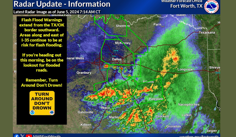
The extensive rainfall led to the NWS issuing Flash Flood Warnings for multiple counties including Dallas, Ellis, and Kaufman. Such events may lead to overflows in urban areas, highways, and underpasses, as per the Hazardous Weather Outlook, prompting alerts like, "Turn around, don`t drown when encountering flooded roads." Impacts noted include the flooding of small creeks and streams, urban areas, highways, streets, and underpasses as well as other poor drainage and low-lying areas. The Flood Advisory remains in effect until 8 AM CDT with expectations of urban and small stream flooding, particularly in Dallas, Ellis, Johnson, and Tarrant counties. Updates and further details can be tracked through the NWS and local news outlets.


