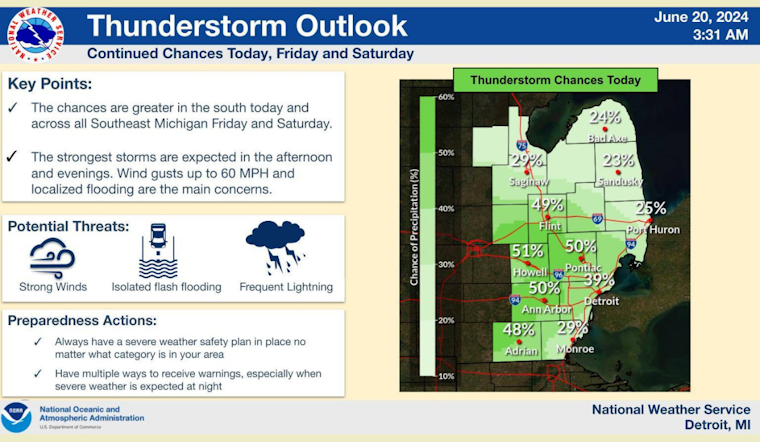
Detroit residents can expect a mixed bag of weather conditions over the coming week, with temperatures hovering consistently near the 90-degree mark accompanied by sporadic chances of showers and thunderstorms. According to the National Weather Service, today will see a 40% chance of rain, mainly after 11 am, under mostly sunny skies, with a high approaching 90 degrees.
The forecast for tonight predicts mostly cloudy skies with temperatures dropping to a comfortable 69 degrees. The calmness after midnight follows a gentle northeast wind of around 6 mph. As we move into Friday, the pattern of potential precipitation continues, with a similar chance for showers and thunderstorms in the afternoon hours and a continuation of warm temperatures near the 90-degree mark.
Over the weekend, Detroiters should prepare for more sun complemented by episodes of possible thunderstorms, particularly in the afternoon and early evening. Saturday's daytime promises mostly sunny conditions, with a high close to 93 degrees and winds that could gust as high as 20 mph. "A chance of showers and thunderstorms before 8pm, then a chance of showers after 2am," forecasts the National Weather Service for Saturday night, estimating a 50% chance of precipitation.
Sunday follows a similar script with a partly sunny disposition and a high again near 90, but it also carries a 50% chance of rain showers and thunderstorms that could potentially break the heat. Clearing is expected Sunday night as the clouds disperse, paving the way for a sunny Monday with the temperature resting at a comfortable 86 degrees. The week begins to close with Tuesday and Wednesday expected to be mostly sunny amidst additional chances of rainfall as Detroit experiences another bout of summer's capriciousness.


