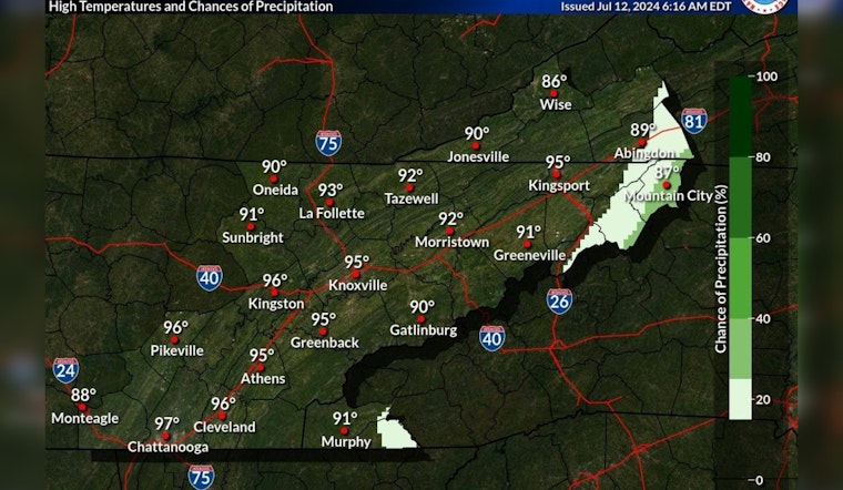
Knoxville is about to experience a sizzling sequence of days, as clear skies and escalating temperatures mark the forecast this week. In what many might see as a typical summer pattern, Knoxville's weather suggests locals should be ready to don their lightest cotton and stay well-hydrated. According to the National Weather Service, the morning fog has given way to the sun, with temperatures expected to hover near the 95-degree mark today.
Outside of a stray shower/storm in higher elevations, dry conditions with highs in the 90s are expected this afternoon. Low RH will help it from feeling too humid and muggy but you should still practice heat safety as the hot conditions are expected to continue into next week. pic.twitter.com/xJPIzQ0hP1
— NWS Morristown (@NWSMorristown) July 12, 2024
As a respite from the morning's foggy embrace, the NWS predicts unfaltering sunshine set to push thermometers to impressive highs. Tonight, the city will cool slightly to a more tolerable 71 degrees. Calm winds are a constant in this forecast, seemingly refusing to provide even the slightest breeze to break the heat that will continue to build up. By Saturday, residents can expect to see their thermostats read as high as 96 degrees, with heat index values daring to tease the verge of triple digits.
The hot streak, as reliable as the calm wind accompanying it, is forecast to persist into the early week. Sunday's continuation of clear skies will bring temperatures up to 97 degrees. The nighttime promises only a slight dip, landing the low at a balmy 73 degrees, clear and calm yet again. Monday is set to be the pinnacle of this heat wave, with the mercury climbing up near the 100-degree point and a light westerly wind at 5 mph.
Come Tuesday, the possibility of rain might just be enough to have residents looking forward to a 20 percent chance of showers and thunderstorms after 2 pm—though the day will remain sunny and hot with highs again near the 99-degree mark, as reported by the National Weather Service. The chance of precipitation holds steady at 20 percent through Tuesday night while temperatures stay put in the mid-70s. However, the latter half of the week sees an increase in storm potential, with showers and thunderstorms becoming likely by Wednesday and maintaining a 60 percent chance of activity through Thursday.
Wet weather or not, the heat will continue to assert itself with Wednesday's highs still around 97 degrees. Thunderstorms may bring some reprieve during the nights, as the minimum temperatures drop to the low 70s. By Thursday, the showers and thunderstorms are expected to continue, as the high temperature retreats only slightly to a still-steamy 92 degrees.


