Michigan residents are bracing for the remnants of Tropical Storm Beryl as the weather system continues moving northward after its landfall in Texas. CBS News Detroit reports that Southeast Michigan is expected to feel the effects on Wednesday, with up to 2 inches of rain anticipated in the region. A weakening Beryl, now downgraded to a Tropical Depression, could still bring about heavy rainfall, especially across parts of West Michigan.
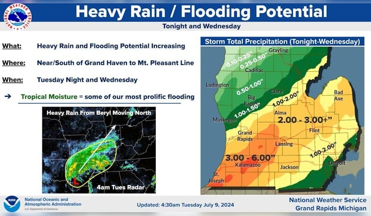
As the storm moves up from Texas, areas around West Michigan are forecasted to see an increase in rainfall reaching totals between 1 to 4 inches, WZZM 13 anticipates, with rainfall concentrated along a Holland – Grand Rapids – Greenville line. Residents near the I-94 corridor could face more severe conditions, encountering 4-6 inches, increasing flood risks. Struggling with the fate of a Tropical Depression, Beryl's capacity to saturate the land should not be underestimated.
The National Weather Service Grand Rapids has already issued a Flood Watch, though some counties such as Muskegon and Mecosta are expected to receive lighter, more manageable rainfall. Bridge Michigan shared that originally a hurricane, Beryl's northern journey is unusual, with effects potentially disrupting conditions from Louisiana to Illinois. The storm has already left an imprint of devastation, causing at least two fatalities in Texas and leaving millions powerless.
"At this time, we can't really pinpoint where we might see flooding, but anytime that you get more than 2 inches of rainfall in a 24-hour period or less, there's certainly potential for flooding," Megan Varcie, a meteorologist for the NWS Detroit office, told Bridge Michigan. With gusts potentially exceeding 30 mph, they also suggest precautions, especially in flood-prone areas. The storm should exit the region by early Thursday morning, having tested the preparedness of communities and infrastructure in its wake.


