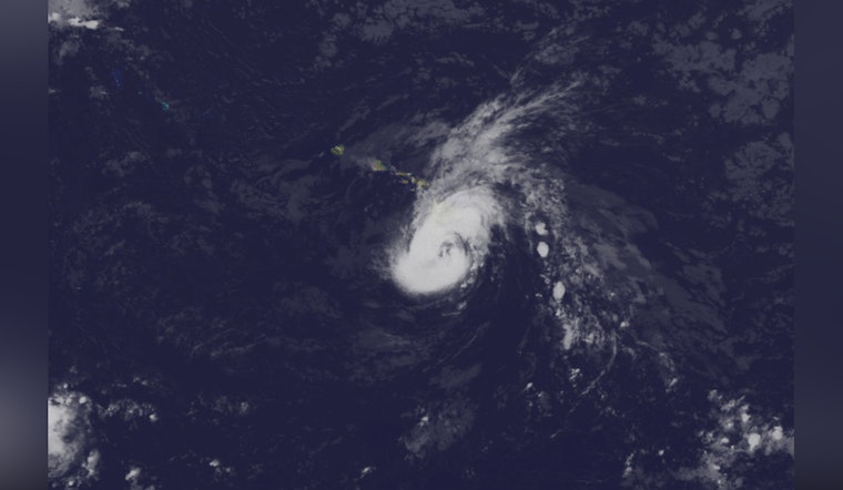
Honolulu residents are bracing for a turbulent day as Hurricane Hone passes just south of Big Island, with forecasters warning of the potential for heavy rainfall, damaging winds, and elevated surf conditions. According to the National Weather Service, the Category 1 hurricane is bringing strong gusty easterly winds and periods of heavy rainfall that will persist through tomorrow; locals are enduring a siege of the elements where water and wind conjoin to test the fortitude of infrastructure and the preparedness of communities.
With the storm's center approximately 60 miles south of South Point, outer rain bands have already soaked the Big Island's windward regions with 4 to 8 inches of rain in the last 24 hours, the flood watch remains in effect until tomorrow evening, as there is an additional 4 to 6 inches of total rainfall with locally higher amounts forecasted especially for windward areas, this info comes alongside reports indicating that moderate to heavy precipitation will continue to affect areas such as Hilo, Puna, and Ka'u through the early part of the week. The extended rainfall could result in localized flash flooding, a concern not only for Big Island residents but also for those on the smaller islands, which might accrue an average of 2 to 4 inches of storm total rain.
Ongoing wind advisories detail the likelihood of gusts reaching 50 to 60 mph in many localized areas with certain exposed valleys and higher elevation areas bracing for potential gusts up to 70 mph; Northeast winds will also strengthen across the state throughout the day with strong downslope winds anticipated over leeward slopes. The high winds have resulted in various weather advisories, including a Wind Advisory until 6 AM HST tomorrow for a span of regions from Niihau and Kauai to Maui and Haleakala Summit.
In the maritime sphere, marine conditions are tumultuous with a Hurricane Warning in effect for waters south of Big Island while a Tropical Storm Warning encompasses all waters adjacent to it, Gale Warnings and a Small Craft Advisory span across the windier waters in and around Maui County and the remaining waters respectively, as the combination of Hurricane Hone's advance and a far-reaching northern high prompts a tight pressure gradient and elevated trade winds. The High Surf Warning, previously issued due to Hone's influence, has been transitioned to a High Surf Advisory for all east-facing shores descriptive of the ebbing yet potent surf generated by the departing hurricane's swell.
For aviators, the journey skyward is fraught with challenges as IFR/MVFR conditions loom over Big Island, AIRMET warnings are in place concerning visibility reductions below 3SM and ceiling heights below 010, with strong surface winds and moderate turbulence as the system's periphery skims overhead - a lasting testament to Hone's unwelcome sojourn sustained winds of 30-40kts with even higher gusts further complicating navigation through airspace that seems almost to push back against the very notion of flight, as the Central Pacific Hurricane Center continues to monitor and issue critical updates vital for those daring the skies.


