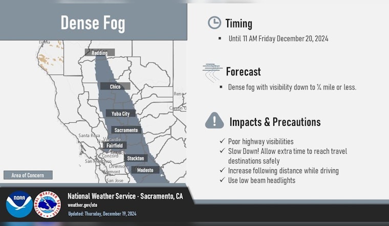
The National Weather Service (NWS) in Sacramento has issued a Dense Fog Advisory for the Sacramento and northern San Joaquin Valley, effective until 11 AM PST today. Commuters are advised to slow down, maintain adequate space between vehicles, and use low-beam headlights in areas of dense fog. Conditions have been particularly poor in the northern Sacramento Valley, with visibility at Redding AP reduced to just 1/4 mile and at Red Bluff AP to 1/2 mile.
Clear skies are not expected to last, as forecasters predict a shift to a wetter pattern starting tomorrow. A series of storms is set to roll in beginning Saturday morning, carrying the first wave of precipitation primarily north of the Sacramento area. The northern Sacramento Valley, southern Cascades, and the Sierra and adjacent foothills will see the heaviest of precipitation, according to the NWS. Rain totals may reach 0.75 to 1.25 inches through early Sunday, while snow levels in the Sierra remain above 6000 feet, limiting accumulation to a dusting to 2 inches.
A brief interlude from the rain is anticipated late tomorrow night into Sunday morning before another wave continues bringing moisture and maintaining high snow levels above 8000 feet. The NWS outlines probabilities ranging from 15-30% in the central and southern Sacramento Valley to 65-90% in the northern sectors and mountain zones for additional precipitation through Monday. Mountain travel is expected to be affected, with primarily wet roads cited as the primary concern.
Compared to the first two systems, the third wave arriving Monday is expected to have more significant impacts, lasting into Christmas Day. With enhanced moisture support, areas including the northern Sacramento Valley and the mountains face a high likelihood of substantial rainfall. Snow levels are forecast to drop to around 5000-6000 feet later in the event, potentially affecting Christmas Eve travel in higher elevations. As per the NWS forecast, NBM probabilities for about 6 inches of snow at elevations of 6000 feet and higher range from 30% to 50%, suggesting a potential need for an advisory on snowfall rates and accumulations. Additionally, southerly winds are expected to strengthen, particularly from Yuba City to Redding and in the Sierra’s mountains and foothills.
Looking further ahead, post-Christmas forecasts anticipate yet another break before the next round strikes late Christmas night. The subsequent system could be cooler, bringing additional widespread precipitation through Thursday into Friday. Despite uncertainties regarding the precise impacts, updated guidance will clarify expectations as the week progresses. As always, NWS advises those with travel plans to stay updated with road conditions and changing weather developments.


