Minneapolis, brace yourself to quickly shift from sunny skies to the potential crisp touch of snowflakes. According to the latest weather updates from the National Weather Service, Minneapolis residents can expect "mostly sunny" weather today with the thermometer topping out near 48 degrees. Come nightfall, the city will be draped in "partly cloudy" conditions as temperatures dip to around 28 degrees.
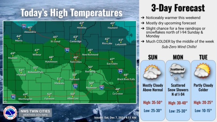
A much welcomed break from the bitter cold arrives in time for the weekend. Afternoon highs are forecast to climb into the 40s and lower 50s under filtered sunshine. Enjoy the brief warm up, as another arctic blast arrives by the middle of next week. pic.twitter.com/aStb4TOneA
— NWS Twin Cities (@NWSTwinCities) December 7, 2024
The weather narrative progresses with a calm Sunday morning, transforming to "mostly cloudy" skies and a high nearing 41 degrees. As Sunday night approaches, skies are slated to gradually clear, hovering at a low near 31 degrees. Residents might need to ready themselves Monday for the atmosphere to significantly change, with a "20 percent chance of snow after noon," while wind gusts could escalate as high as 30 mph amidst increasing clouds, as detailed by the National Weather Service.
"Mostly cloudy" conditions will carry through Tuesday with daytime temperatures peaking near 23 degrees and plunging to nearly 10 degrees at night. Despite the cloudy overture, Wednesday promises a glimpse of respite with "mostly sunny" weather, yet the high is to only manage to ascend near 15 degrees. The subsequent evenings through Friday extend a slightly milder theme, as nighttime lows incrementally rise from 4 to around 16 degrees, cresting to a "mostly cloudy" high of 33 degrees on Friday, as forecasted by the National Weather Service.


