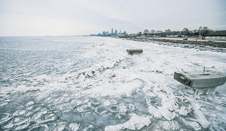
Cleveland braces for a blast of wintry weather as a strong cold front sweeps through, with the National Weather Service in Cleveland issuing a series of alerts for snow and chill. According to the latest forecast update, the city will feel the full force of this Arctic plunge across the region, which is expected to bring a precipitous drop in temperatures and snow showers and squalls, particularly hammering the so-called Snowbelt.
The onset of this weather event was marked by temperatures falling through the 20s, pushed by the cold front moving eastward of the Interstate 77 corridor. The National Weather Service in Cleveland, cited in their forecast discussion, reports that "an upper level trough will dig across the Great Lakes region over the next couple of days," promoting lake effect snow for the primary snowbelt. Peculiarly positioned, the low-level flow aligns itself from the west-southwest, yielding cold air advection with gusty winds up to 30 mph today.
For those in Erie County, PA, the conditions have warranted an upgrade to a Lake Effect Snow warning as squalls intensify, significantly impacting the region. An important lake-shore effect will continue, resulting from an easterly surface trough that may linger into midweek. This will generate additional snowfall accumulations for the primary snowbelt with a possibility of local enhancement, thanks to what might develop into a Lake Huron connection.
The National Weather Service continues to monitor the situation as the area grapples with significant snowfall and gripping cold temperatures. "Widespread single digits are expected Wednesday night," as per the National Weather Service forecast discussion, with wind chill values dropping to negative values, engendering the coldest wind chill temperatures expected on Wednesday night, with conditions expected to remain active through the latter week, as the system transitions back to more frigid temperatures and potential for more lake effect snow.
Marine interests aren't spared; the winds are set to create hazardous conditions for Lake Erie, with a Small Craft Advisory in effect for parts of the lake due to expected high waves. A Low Water Advisory was also issued for the western basin of Lake Erie, described in the NWS marine forecast, where water levels at Toledo were reported at 7.1 inches above the low water datum, reflecting a concern for safe navigation.
As the cold front continues to influence Northeast Ohio and Northwest Pennsylvania, residents are urged to prepare for severe winter conditions, heed warnings, and ensure safety while navigating the tough weather ahead.


.jpg)