The residents of Minneapolis are set to experience a chilly week, according to forecasts from the National Weather Service. With temperatures barely rising above the freezing point, the city will see mostly sunny skies today, with a high near 12 degrees, according to forecasts from the National Weather Service. But don't let the sun deceive you–wind chill values could dip as low as -13, with a persistent north wind around 10 mph.
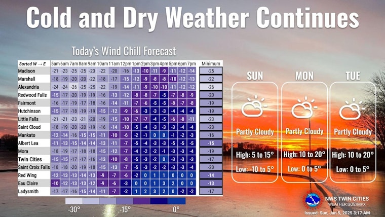
This morning will be very cold with wind chills in the -20s across western Minnesota to -10 further south and east. Our cold and dry weather will continue through the first half of the week with temperatures warming a few degrees by Monday and Tuesday. #mnwx #wiwx pic.twitter.com/GyShKhb2sq
— NWS Twin Cities (@NWSTwinCities) January 5, 2025
As reported by the National Weather Service, the low tonight will hover around 2 degrees, with the north wind continuing at a speed of 5 to 10 mph. Monday is expected to bring a slight respite from the cold with sunny conditions and a high near 16, although the north-northwest wind will persist at around 5 mph.
Heading into Monday night, the forecast indicates primarily cloudy skies, settling at a low of around 8 degrees with a calming northwest wind post-midnight. The trend of cloud cover continues into Tuesday, but those clouds are predicted to clear gradually, yielding to sunny skies and a high near 17, while the north-northwest wind blows at 5 to 10 mph.
Partly cloudy conditions are anticipated on Tuesday night with temperatures dropping to around 4 degrees, accompanied by a light northwest wind at around 5 mph. Going into mid-week, Wednesday will be partly sunny with a high approaching 17 degrees, as per the National Weather Service. A southwesterly wind at about 5 mph will emerge, forecast.gov mentions.
As the week progresses, the city will see a shift toward milder weather. Thursday's predictions show partly sunny skies with higher temperatures, around 28 degrees, under a south wind of 5 to 10 mph. Thursday night, however, will see the return of mostly cloudy conditions and a low near 19, with winds transitioning to a westerly direction.
On Friday, expect a continuation of cloud coverage and a high of roughly 25, with gusty west-northwest winds up to 10 mph, as detailed by the NWS. The evening will likely mirror the daytime, presenting mostly cloudy skies and lows around 13 degrees alongside a west-northwest wind. The weekend forecasts similarly cool and partly sunny conditions, with highs saturating in the mid-20s and west winds keeping at a gentle pace of approximately 5 mph.


