Minneapolis residents are gearing up for a soggy and thunderous week ahead, as the National Weather Service in Twin Cities/Chanhassen has issued a forecast predicting a range of inclement weather conditions. Over the next few days, they're forecasting showers, thunderstorms, and even potential hazards from severe weather conditions within central and southern Minnesota, and parts of west central Wisconsin. According to the National Weather Service, the Minneapolis metro area is slated to see "showers and thunderstorms" with "areas of smoke before 2pm" today, followed by a continued chance of precipitation at a steady "80%".
Scattered showers and thunderstorms become widespread this afternoon, with the heaviest rain from this afternoon through Friday morning.
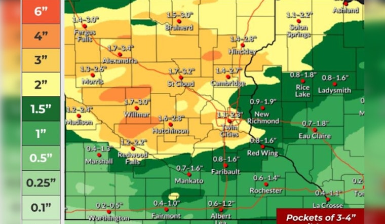
— NWS Twin Cities (@NWSTwinCities) June 12, 2025
Localized flooding is possible with high end amounts over 4'' possible across mainly central MN. #mnwx #wiwx pic.twitter.com/drqWsjGlt5
Those in southern MN should be on alert this afternoon for "a few severe storms" as a warm front advances from Iowa, bringing with it the possibility of "large hail and damaging wind gusts," as reported by the NWS Hazardous Weather Outlook. As evening settles, the likelihood of precipitation increases to "90%" and new amounts of rain could total up to half an inch, making the situation all the more urgent for residents to prepare for potential flooding and related storm damages.
Beyond this immediate storm system, an Air Quality Alert remains in effect due to the pervasive presence of smoke from Canadian wildfires, which is significantly impacting air quality in the area. The Minnesota Pollution Control Agency warns that sensitive groups, including "people with lung disease (including asthma), heart disease, and children and older adults, may experience health effects" as levels of fine particles in the air reach the "Unhealthy for Sensitive Groups category." This smoke is anticipated to linger until at least 11 PM CDT Thursday, even as rain may start to wash some of it away.


