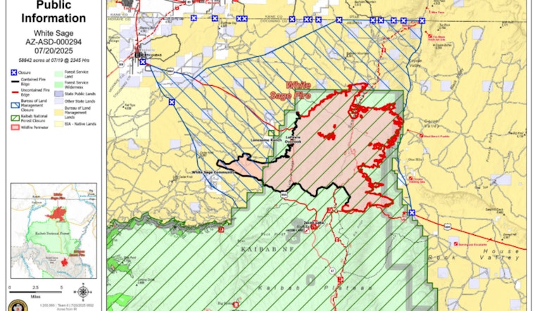
The ongoing battle against the White Sage Fire has firefighters scoring new achievements, as containment of the blaze rises to 31%, marking a 4% increase from the previous day. The fire's footprint remains unchanged at 58,639 acres, with crews benefiting from mild weather that has assisted in their efforts on the ground. However, as the forecast suggests a shift towards warmer, drier conditions, the potential for increased fire behavior looms as the vegetation becomes primed to burn, according to the State of Arizona.
Efforts have been concentrated on establishing and reinforcing containment lines, especially on the western and southern fronts. Despite these efforts, disruptions like Highway 89A's closure continues, as firefighters work to mitigate hazards, such as removing trees weakened by the fire. In a statement obtained by the State of Arizona, authorities stressed that this work is crucial to ensure that when the roadway reopens, it will be safe for travelers.
On the fire's periphery, crews are focused on various tasks—from patrolling for emerging threats to engagement in suppression repair. This includes reseeding with native plants and dismantling dozer berms, actions that are essential not just for containment, but also for the long-term rehabilitation of the land. Meanwhile, to the north, the diligence of fire crews is allowing for quicker progress as they construct direct firelines through areas dominated by smaller pinyon pines, as reported by the State of Arizona.
The strategic use of controlled burns has also played a role in the management of this wildfire. Firefighters carried out successful burn operations north of Highway 89A, which resulted in creating barriers of already-burnt fuel, thereby halting the advancement of the fire. Moreover, two lightning-sparked fires that emerged to the south were promptly contained, preventing any significant development, as per the State of Arizona.
As for weather considerations, no rainfall is on the horizon, with moderate winds anticipated. Smoke may be visible from parts of the controlled burns, particularly in the southeast and east. Although moderate fire activity has been reported, it's expected to rise over the next few days. Coconino County continues to regularly update evacuation information, advising residents and the public to remain apprised of the situation through the County's Evacuation Map, as detailed by the State of Arizona.
For those seeking more detailed updates, the Fire Information Line is available at (928) 218-4240, from 8 a.m. to 8 p.m., or queries can be directed via email to [email protected]. The Incident Information System (InciWeb) alongside BLM Arizona and Kaibab NF Facebook pages also provide ongoing updates about the White Sage Fire, as reported by the State of Arizona.


