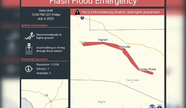
As South Texas grapples with the start of the holiday weekend, residents are facing a significant flooding threat, with the National Weather Service (NWS) confirming the situation has become particularly grave in Kerr County. According to an update from KENS 5, an estimated 5-10 inches of rainfall has caused major flooding, resulting in flooded low water crossings and the Guadalupe River at Hunt reaching major flood stage. A Flash Flood Emergency is in effect for several affected areas including Kerrville, Ingram, and Center Point until noon.
The region west of San Antonio is expected to slowly dry out following the holiday, but not before it continues to face the aftermath of what has already occurred. The flood watch remains in effect, extending to Bexar, Kendall, Val Verde, Edwards, Real, Kerr, Bandera, Kinney, Uvalde, and Medina counties until 1 p.m., on Friday. In a statement obtained by KTSA, localized flooding is possible "where the heaviest rainfall occurs."
Meanwhile, as a part of their ongoing coverage, KENS 5 reported that the Guadalupe River's surge has brought on the second highest height on record, surpassing levels seen in the flood of 1987. The National Weather Service has stated, "This is a very dangerous and life-threatening flood event along the river," urging those in the affected areas to move to higher ground. AAA Texas is expecting millions of drivers to hit the road for the Fourth of July celebrations, which could be disrupted by the adverse weather conditions.
The National Weather Service warns that scattered thunderstorms may bring heavy rain and strong winds. Areas under a Flood Watch face a Level 2 out of 4 risk for flash flooding. A Flood Watch means flooding is possible, while a Flood Warning means it's already happening. Despite the weather concerns, the evening of July 4 is expected to be partly cloudy with temperatures in the mid to upper 80s—good news for fireworks shows, as per KENS 5.


