In an effort aligned with forest management and community safety, the Bureau of Indian Affairs Fort Apache Fire Management and the White Mountain Apache Tribe are taking to the skies with Unmanned Aerial Systems (UAS). These UAS are enhancing the prescribed burn operations by providing aerial ignition across the Fort Apache Indian Reservation, as reported on November 14th, 2025. This technological stride marks a first for the BIA Agency Western Region, and it promises to enhance both the precision of operations and the safety of ground crews.
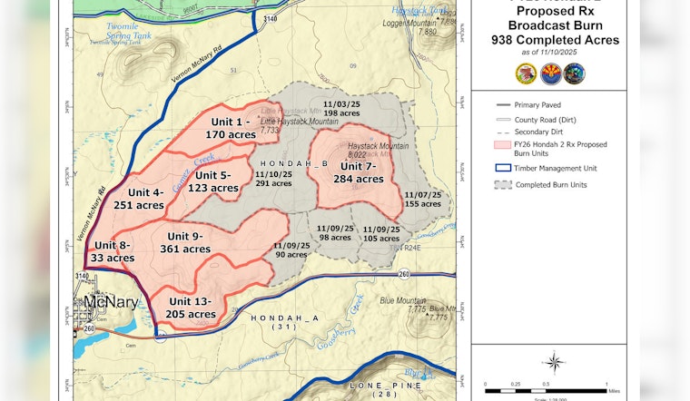
Monitoring in the Coyote and Maverick units will persist, according to the same source. While activities in the Hon-Dah Unit are currently suspended, a burn encompassing 668 acres is planned in the Elk Canyon Unit. Yesterday, the Odart Unit, with 1,014 acres scorched, and the Turkey Creek Unit, with 1,231 acres, both of which will continue to be monitored. Additionally, Tonto South Unit is slated for a 1,000-acre ignition, a part of a broader effort to bolster forest health and mitigate the risk of future wildfires.
These prescribed burns serve a dual purpose: they mitigate the threat of future high-intensity wildfires and foster an environment for native vegetation to flourish. In a span of nine days, the operations have successfully treated 10,000 acres, which represents a considerable progression in the restoration of forest and watershed areas.
With prescribed burns, there's an advisory for those traveling near Highway 260. Officials anticipate that smoke will dissipate quickly, but drivers, as well as woodcutters and hunters using back roads, are expected to exercise heightened caution during burn days, as reported by the source.


