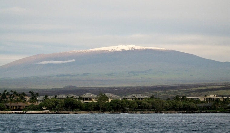
The latest weather forecast from the National Weather Service in Honolulu indicates a moist and windy week for the Hawaiian Islands. Increasing chances of heavy showers are expected Tuesday night through Wednesday, particularly impacting the windward areas of Maui and the Big Island. A Winter Weather Advisory is also in place until 6 PM HST this evening for the summits of Mauna Loa and Mauna Kea, where a mix of rain and snow is possible due to freezing levels hovering between 13,000 to 14,000 feet.
An upper-level trough and a surface trough southwest of the Big Island are anticipated to generate unstable atmospheric conditions, leading to potential heavy rain south of the Big Island. The forecasts, however, are currently mixed, with the Global Forecast System (GFS) predicting greater intensity of rainfall than the European Centre for Medium-Range Weather Forecasts (ECWMF). According to the National Weather Service, "Forecast rainfall totals currently range from around an inch with the ECMWF's weaker forcing to around two inches from the GFS." A Flood Watch may be necessitated if these conditions materialize, but limitations in current trends suggest the flood threat could remain limited.
Elsewhere in the island chain, strong trade winds fueled by a building surface high north of the state will usher in showers affecting both windward and leeward regions. The probability of flooding across the smaller islands remains low due to the swift movement of these showers and an absence of significant atmospheric forcing. Later in the week, a brief respite with stable and drier trade wind conditions is foreseen on Friday, only to be followed by the likelihood of more showers as a cold front moves towards the islands over the weekend.
Aviation concerns include strengthening trades and the possibility of low cloud ceilings and enhanced trade wind showers, particularly over windward and mountainous areas. "IFR/MVFR conds are possible in these heavier SHRA," the National Weather Service reports, indicating that some locations on the state's western side may stay in the Visual Flight Rules (VFR) category. The maritime sector is also bracing for a front northwest of Kauai, which is expected to weaken the winds today but may produce near gale-force winds as it lifts northward tonight and tomorrow.
From a marine perspective, surf conditions are projected to rise, with northern and western-facing shores expected to experience elevated surf heights this week, possibly reaching High Surf Advisory levels by Wednesday. A decline is anticipated towards the weekend, though another moderate, long-period northwesterly swell may keep surf heights above average. As the new high-pressure system builds north of the state, choppy conditions along eastern shores might escalate to near advisory thresholds, while the situation remains calm on southern shores due to minimal swell activity.
In terms of fire weather, the heightened humidity and moderate trade winds are likely to keep the risk below critical levels, despite the wet conditions and potential for heavy rainfall impacting recent burn areas on the Big Island. Residents and visitors are advised to remain updated on the evolving weather situation by checking the National Weather Service.


