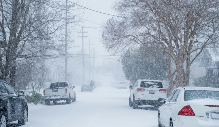
St. Louis is bracing for a frosty mix of wintery elements as the National Weather Service (NWS) St. Louis issued a Winter Weather Advisory, remaining in effect until midnight CST tonight; heavy snowfall and blustery winds are set to converge upon the region. According to the Winter Weather Advisory by the NWS, residents should expect snow accumulations between 2 and 4 inches, compounded by the force of winds gusting as high as 35 mph, laying the groundwork for possible slippery road conditions across portions of south central and southwest Illinois as well as central, east central, and northeast Missouri.
The immediate forecast for today indicates a messy mélange: rain and snow mixed with sleet before the afternoon, to be followed by strict rainfall as the system matures, with the snow possibly coming down in heavy bouts, accumulation of snow and sleet could reach 2 to 4 inches with a 100% chance of precipitation for the day, the high is expected to hover near 40 degrees, amidst southeast winds rocketing 11 to 17 mph and gusting to 33 mph. Tonight, rain chances drop to 50% before skies clear post-9pm, though temperatures are predicted to dip near 24 degrees, with southern winds shifting west and maintaining their robust gusts.
Moving into the initial phase of next week, the outlook is leaning towards cloudy conditions with sporadic chances of snow, especially by Monday afternoon where there's a predicted 20 percent chance after noon. "Accumulating snow is expected through this evening," the Hazardous Weather Outlook reports, prompting the local authorities to encourage the community to keep vigilance, especially on the roads. For those seeking the latest road conditions, resources are available at www.gettingaroundillinois.com for Illinois, and for Missouri, at traveler.modot.org/map, or by direct call to 1-888-275-6636.
Concluding the week, chances of rain as of Friday sit at a modest 20 percent, with temperatures forecasted to reach a high close to 38 degrees, while nighttime is expected to bring mostly cloudy conditions and a low around 21 degrees. Spotters in the region are being urged to report any significant snowfall accumulation to the NWS St. Louis, as it serves vital for keeping the wider public informed and prepared. For an extended outlook, no hazardous weather is expected beyond this event, signaling a bit of reprieve for Missouri and Illinois residents after the current winter tumult quiets down.


