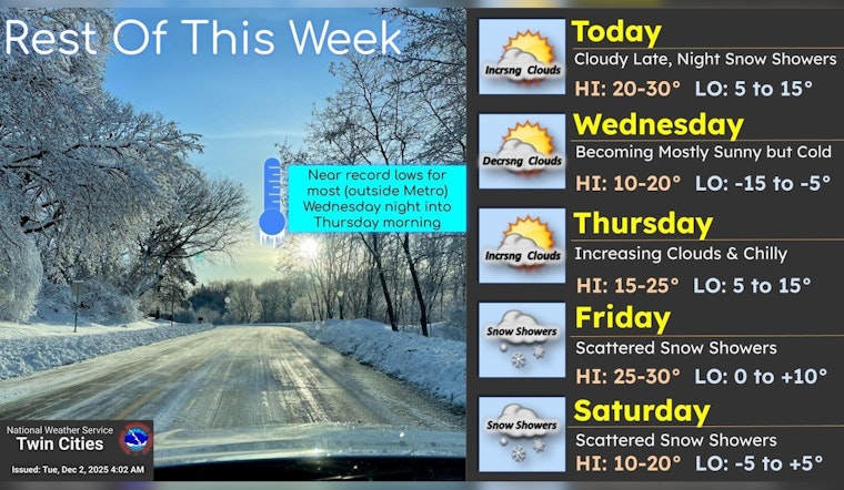
Minneapolis residents should gear up for a brisk week ahead, as the National Weather Service forecasts patchy freezing fog and a chance of flurries starting this afternoon. With temperatures expected to peak at a cool 24 degrees, the south-southwest wind flowing at 5 to 10 mph won't offer much solace from the chill.
As night falls, the chance of snow rises to 30 percent, mainly occurring before 2 am, while a cloudy sky will hold the low around 15 degrees. Also, the south wind shifts to a north-northwest breeze post-midnight, leaving locals to wrap up warm as they transition through the evening hours. According to the NWS, the remainder of the week mirrors today's chill with a gradual clear-up on Wednesday, leading to mostly sunny skies amidst a temperature drop to about 10 degrees by late afternoon, a testament to the season's grip on the city.
Thursday offers little reprieve, promising mostly sunny conditions but with highs stubbornly capping near 16 degrees; a modest south wind of 5 to 10 mph will accompany the daylight hours. As indicated by the Hazardous Weather Outlook, spotters won't need to be activated today or tonight. However, a light dusting of snow is possible tonight, especially across western Wisconsin and eastern Minnesota, setting a prelude to the tentative forecasts projected for the city of Minneapolis and its suburban enclaves.
Looking ahead, snow chances linger into the weekend, with a 40% chance on Friday and 20% on Saturday. Any accumulation is expected to be light. Wind chills could dip to around –13 degrees Wednesday night, offering an early reminder of the season’s harsher temperatures. Rounding out the week, Sunday is expected to bring partly sunny skies with a high near 15 degrees. Temperatures will edge up slightly on Monday, when there’s a 20% chance of snow and highs near 25, the NWS noted.


